
WSR-57 radar antenna from NOAA
WSR-57 radars were the USA's main weather surveillance radar for over 35 years.[1] The National Weather Service operated a network of this model radar across the country, watching for severe weather.
History[]
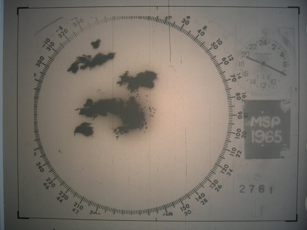
Radar image of tornado-producing supercells over Minneapolis, 1965
The WSR-57 (Weather Surveillance Radar - 1957) was the first 'modern' weather radar. Initially commissioned at the Miami Hurricane Forecast Center, the WSR-57 was installed in other parts of the CONUS (continental United States).[2] The WSR-57 was the first generation of radars designed expressly for a national warning network.[3]
The WSR-57 was designed in 1957 using World War II technology. It gave only coarse reflectivity data and no velocity data, which made it extremely difficult to predict tornadoes.[2] Weather systems were traced across the radar screen using grease pencils. Forecasters had to manually turn a crank to adjust the radar's scan elevation, and needed considerable skill to judge the intensity of storms based on green blotches on the radar scope.[1]
The military designation for the WSR-57 is AN/FPS-41.[2]
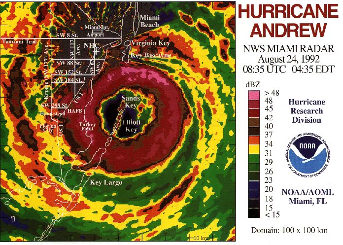
NOAA has pictures of the Charleston, SC WSR-57 radar image of Hurricane Hugo in 1989. Located the National Hurricane Center (NHC), Hurricane Andrew in 1992 blew the WSR-57 dish off their roof. The NHC report on Hurricane Andrew shows its last radar image, as well as images from nearby WSR-88D radars. As the network of WSR-57 radars aged, some were replaced with WSR-74S models of similar performance but with better reliability. WSR-57 operators sometimes had to scramble for spare parts no longer manufactured in this country.[1] 128 of the WSR-57 and WSR-74 model radars were spread across the country as the National Weather Service's radar network until the 1990s.[4] They were gradually replaced by the WSR-88D model (Weather Surveillance Radar - 1988, Doppler), constituting the NEXRAD network.
The last WSR-57 radar in the United States was decommissioned on December 2, 1996.[1]
Radar sites[]
The 66[1] former sites of the WSR-57 include[2][5][6][7] the following:
| Site (Site ID) | Commissioned (Date / Chronological Rank) |
Decommissioned |
|---|---|---|
| Miami, FL (MIA) Moved to Coral Gables in 1967. |
June 26, 1959 1st |
August 24, 1992 Destroyed during Hurricane Andrew. |
| Kansas City, MO (MCI) The dome still resides downtown. |
1959 2nd |
November 9, 1995 |
| Charleston, SC (CHS)[1] | 1959 About 16th |
December 2, 1996 |
| Key West, FL (EYW?) | Early 1960 Among first 31 |
Early 1980s Replaced by a WSR-74S. |
| Wichita, KS (ICT) | June 22, 1960 Among first 31 |
November 9, 1995 |
| Cincinnati, OH (CVG) (Covington, KY) at the Greater Cincinnati Airport. |
1960 (testing in June) About 16th |
June 21, 1996 |
| St. Louis, MO (STL) | July 1960 Among first 31 |
June 19, 1996 |
| Wilmington, NC (ILM) | Before September 1960 Among first 31 |
November 16, 1995 |
| Tampa Bay Area, FL (TBW) | 1960 Among first 31 |
November 9, 1995 |
| Galveston, TX (GLS) | 1960 Among first 31 |
May 22, 1995 |
| Brownsville, TX (BRO) | March 1961 About 16th |
February 28, 1996 |
| Fort Worth, TX (FTW) moved to Stephenville, TX (SEP) in October 1973. |
April 5, 1961 Among first 31 |
August 1, 1995 |
| Detroit, MI | September 12, 1961[8]
Among first 31 |
Replaced with a WSR-74S. |
| Amarillo, TX (AMA) | 1961 Among first 31 |
September 15, 1994 |
| Norman, OK - NSSL Research radar; not part of the national network. |
1962? Probably not counted among first 31 |
1980s |
| Catalina Island, CA (STC?) a.k.a. Santa Catalina - atop Blackjack Mountain. |
Early 1963? Among first 31 |
1960s |
| Little Rock, AR (LIT was the WSR-57 designator. LZK is the WSR-88D and WFO Designation.) | 1959 Among first 31 |
Moved to North Little Rock Airport with NWSFO in 1975. Final decommissioning was June 8, 1995 |
| Sacramento, CA (SAC) | Early 1960s Among first 31 |
August 24, 1995 |
| Washington, D.C. (IAD) At Washington Dulles International Airport, Dulles, VA. |
Early 1960s Among first 31 |
Early 1980s Replaced by a WSR-74S at Patuxent River, MD. |
| Apalachicola, FL (AQQ) | Early 1960s Among first 31 |
January 19, 1996 |
| Daytona Beach, FL (DAB) | Early 1960s Among first 31 |
December 1, 1995 |
| Des Moines, IA (DSM) | Early 1960s Among first 31 |
May 7, 1996 |
| Chicago, IL (?) | Early 1960s Among first 31 |
Early 1980s Replaced by a WSR-74S at Marseilles, IL |
| Evansville, IN (EVV) | Early 1960s Among first 31 |
July 12, 1996 |
| Lake Charles, LA (LCH) | Early 1960s Among first 31 |
October 12, 1995 |
| New Orleans, LA (MSY) At Slidell, LA |
Early 1960s Among first 31 |
August 22, 1995 |
| Minneapolis, MN (MSP) At the airport |
Early 1960s Among first 31 |
April 3, 1996 |
| Missoula, MT (MSO) At Point Six Mountain |
Early 1960s Among first 31 |
December 12, 1995 |
| Atlantic City, NJ (ACY) | Early 1960s Among first 31 |
September 13, 1995 |
New York City, NY (NYC) |
Early 1960s Among first 31 |
September 26, 1995 |
| Oklahoma City, OK (OKC) | Early 1960s Among first 31 |
July 25, 1994 |
| Portland, ME (?) At Brunswick Naval Air Station |
November 1969 | Replaced by a WSR-74S. |
| Jackson, MS (JAN) At Jackson International Airport at Thompson Field. |
1969 | June 21, 1995 |
| Limon, CO (LIC) | 1960s | December 22, 1995 |
| Garden City, KS (GCK) | 1960s | September 1, 1994 |
| Grand Island, NE (GRI) | 1960s | January 19, 1996
Has been torn down to make way for a new airport termial |
| Buffalo, NY (BUF) | 1960s | February 14, 1996 |
| A note on the chronological ranks - The first 31 were built through the early 1960s, at existing Weather Bureau offices. 14 were along the Gulf and Atlantic coasts. 11 were in the Midwest. 3 were inland of the East Coast, and California and Montana had one each on mountaintops. The late 1960s saw 14 more built east of the Rockies. | ||
| Nashville, TN (OHX) At Old Hickory Lake |
November 1970 | January 19, 1996 |
| Memphis, TN (MEG?) At the Millington Naval Air Station. |
February 1971 | December 1985 Replaced by a WSR-74S. |
| Medford, OR (MFR) | June 1971 | August 30, 1996 |
| Centreville, AL (CKL) |
June 27, 1995 | |
| Pensacola, FL (PNS/NPA) | January 19, 1996 | |
| Athens, GA (AHN) | September 13, 1996 | |
| Waycross, GA (AYS) | January 19, 1996 | |
| Cape Hatteras, NC (HAT) | December 6, 1995 | |
| Pittsburgh, PA (PBZ) | May 10, 1995 | |
| Huron, SD (HON) | October 30, 1971 [9] | November 4, 1996, now a live dual-polarization for KELO-TV |
| Bristol, TN (TRI) | January 19, 1996 | |
| Midland/Odessa, TX (MAF) | June 4, 1996 | |
| Neenah, WI (EEW) | 1972? | November 2, 1995 |
| Hondo, TX (HDO) | July 1971[10] Last (66th) |
March 14, 1996 |
Radar properties[]

Last image of the Miami's WSR-57 blown off by Hurricane Andrew.
- The radar uses a wavelength of 10.3 cm.[11] This corresponds to an operating frequency of 2890 MHz. This frequency is in the S band, which is also used by today's weather radar network.
- WSR-57 radars had the following interesting statistics:[11]
- Dish diameter: 12 feet (3.7 m)
- Power output: 410,000 watts
- Maximum range: 915 km (494 nm)
References[]
- ↑ 1.0 1.1 1.2 1.3 1.4 1.5 "Weather service retires last of old radars". USAToday. November 4, 1999. https://www.usatoday.com/weather/wsr57.htm. Retrieved 2008-03-27.
- ↑ 2.0 2.1 2.2 2.3 "History of Operational Use of Weather Radar by U.S. Weather Services". AMS. http://ams.allenpress.com/perlserv/?request=get-document&doi=10.1175%2F1520-0434(1998)013%3C0219%3AHOOUOW%3E2.0.CO%3B2&ct=1. Retrieved 2008-03-27.
- ↑ "Historic Tornado Warning Conference Launched Nation's First Weather Radar Network". NOAA. http://www.noaanews.noaa.gov/stories/s1163.htm. Retrieved 2008-03-27.
- ↑ "An Overview of NEXRAD Products Available via UCAR's Unidata Program". wsicorp.com. Archived from the original on April 20, 2008. https://web.archive.org/web/20080420195322/http://sysu1.wsicorp.com/unidata/intro.html. Retrieved 2008-03-27.
- ↑ "Assessment of Nexrad Coverage and Associated Weather Services (1995)". books.nap.edu. http://books.nap.edu/books/NI000004/html/9.html. Retrieved 2008-03-27.
- ↑ "Report of US Weather Bureau Studies in Radar Hydrology". cig.ensmp.fr. http://www.cig.ensmp.fr/~iahs/redbooks/a065/065028.pdf. Retrieved 2008-03-27.
- ↑ "NWS Offices Past and Present". dm.net. http://www.dm.net/~chris-g/nwshist.html. Retrieved 2008-03-27.
- ↑ National Weather Service Detroit/Pontiac Forecast Office. "Beecher 50th Anniversary Commemoration". National Weather Service Central Region Headquarters. http://www.crh.noaa.gov/dtx/1953beecher/radarWSR57.php. Retrieved 2014-06-26.
- ↑ https://www.newspapers.com/newspage/21670634
- ↑ "HONDO, TEXAS". utexas.edu. http://www.tshaonline.org/handbook/online/articles/hfh07. Retrieved 2008-03-27.
- ↑ 11.0 11.1 "WSR - Weather Surveillance Radar". weather.cod.edu. http://weather.cod.edu/sirvatka/radar.html. Retrieved 2008-03-27.
The original article can be found at WSR-57 and the edit history here.