| Sheerness | |
|---|---|
| Population | 11,654 |
Sheerness /ʃɪərˈnɛs/ is a town located beside the mouth of the River Medway on the north-west corner of the Isle of Sheppey in north Kent, England. With a population of 13,000 it is the largest town on the island.
Sheerness began as a fort built in the 16th century to protect the River Medway from naval invasion. In 1665, plans were first laid by the Navy Board for a Royal Navy dockyard where warships might be provisioned and repaired, a site favoured by Samuel Pepys, then Clerk of the Acts of the navy, for shipbuilding over Chatham.[1] After the raid on the Medway in 1667, the older fortification was strengthened; in 1669 a Royal Navy dockyard was established in the town, where warships were stocked and repaired until its closure in 1960.
Beginning with the construction of a pier and a promenade in the 19th century, Sheerness acquired the added attractions of a seaside resort. Industry retains its important place in the town and the port of Sheerness is one of the United Kingdom's leading car and fresh produce importers. The town is the site of one of the UK's first co-operative societies and also of the world's first multi-storey building with a rigid metal frame.
History[]
The first structure in what is now Sheerness was a fort built by order of Henry VIII to prevent enemy ships from entering the River Medway and attacking the naval dockyard at Chatham. In 1666 work began to replace it with a stronger fort. However, before its completion, this second fort was destroyed during the 1667 Dutch raid on the Medway.[2] The Secretary of the Admiralty, Samuel Pepys, subsequently ordered the construction of a naval dockyard at Sheerness as an extension to that at Chatham,[3] where naval ships would be maintained and repaired. Low quality housing and the poor water supply near the dockyard led to a lack of workers and caused construction delays, and the first dry-dock was not completed until 1708. Using materials they were allowed to take from the yard, dockyard construction workers built the first houses in Sheerness. The grey-blue naval paint they used on the exteriors led to their homes becoming known as the Blue Houses. This was eventually corrupted to Blue Town, the modern name of the north-west area of Sheerness.[2]

Sheerness Dockyard: Naval Terrace and Church.
Following the Napoleonic Wars, an opportunity was taken to rebuild the Dockyard. The site was leveled in 1815, and over the next 15 years the new Dockyard was laid out, according to meticulous plans drawn up by John Rennie. A full scale model created at the time, which still exists, shows how much of the original remains. The principal architects were Edward Holls and his successor George Taylor who was already an established architect with a practice in London and had been responsible for some of London's most fashionable squares. In all the project cost £2,586,083 and was completed by 1830, providing fine terraced houses for naval officers. Sheerness was unusual among Dockyards in the unity and clarity of its design, having been built in one phase of construction, of a single architectural style according to a unified plan (rather than developing piecemeal over time).[4]
From the completion of the dockyard until 1960 Sheerness was one of the bases of the Nore Command of the Royal Navy, which was responsible for protecting British waters in the North Sea. The command was named after the Nore sandbank in the Thames Estuary, about 3 miles (5 km) east of Sheerness.[5] In 1797, discontented sailors in the Royal Navy mutinied just off the coast of Sheerness.[6]

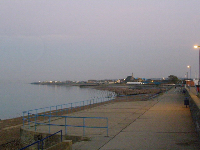
Sheerness beach with the chimney of the Grain power station in the distance
By 1801 the population of the Minster-in-Sheppey parish, which included both Sheerness and the neighbouring town of Minster, reached 5,561.[7] In 1816, one of the UK's first co-operative societies was started in Sheerness, chiefly to serve the dockyard workers and their families. The Sheerness Economical Society began as a co-operative bakery but expanded to produce and sell a range of goods.[8] By the middle of the 20th century, the society had spread across the Isle of Sheppey and had been renamed the Sheerness and District Cooperative Society.[9]
In the early 1820s a fire destroyed many buildings at the dockyard, including all the Blue Houses. New houses and a major redevelopment of the dockyard followed. On 5 September 1823, the rebuilt dockyard was formally opened by the Duke of Clarence (later William IV). A high brick wall and a moat were constructed around the yard to serve as a defence measure and remained in place until the end of the 19th century. As the settlement expanded eastwards, away from the dockyard and the Blue Houses, the wider area became known as Sheerness,[2] taking its new name from the brightness or clearness of the water at the mouth of the River Medway.[10] Completed in 1860 and still standing today, the Sheerness Boat Store was the world's first multi-storey building with a rigid metal frame.[2] In 1863, mains water was installed in the town, and the Isle of Sheppey's first railway station opened at the dockyard. Towards the end of the 19th century, Sheerness achieved official town status and formed its own civil parish, separate from Minster-in-Sheppey.[2] The 1901 Census recorded the Sheerness parish as having 18,179 residents and 2,999 houses.[11]
The town's low rainfall and ample sunshine made it popular as a seaside resort, with tourists arriving by steamboat and train.[10] The Sheppey Light Railway opened in 1901, connecting the new Sheerness East station with the rest of the island. However, by 1950, lack of demand led to the railway's closure.[12] The Sheerness and District Tramways, which opened in 1903, only lasted until 1917.[13]

Terraced houses near the seafront
In 1944 the United States cargo ship SS Richard Montgomery ran aground and sank 1 mile (1.6 km) off the coast of Sheerness, with 3,172 tonnes of explosives on board. Due to the inherent danger and projected expense, the ship and its cargo have never been salvaged; if the wreck were to explode, it would be one of the largest non-nuclear explosions of all time. A 2004 report published in New Scientist warned that an explosion could occur if sea water penetrated the bombs.[14]
In March 1960 the Royal Navy ceased operating the Sheerness dockyard and the Medway Port Authority took over the site for commercial use. The dockyard closure led to thousands of job losses, and most of the nearby houses and shops in the Bluetown area were eventually abandoned and demolished.[3] By the 1961 census, the population of Sheerness had fallen to 13,691.[11] The dockyard closure also led to the decline of the Sheerness and District Cooperative Society, as many of its members were dockyard workers. At the time, the society was the island's main retailer, but it has since been reduced to a few shops and been merged with a larger society.[9]
As of 2007, Bluetown is an industrial area, and Sheerness has become the largest port in the UK for motor imports.[2] Following the closure of the Dockyard, several of its historic buildings were demolished (including the listed Admiralty House and quadrangular Great Store); others were left to decay. In the early 21st century a concerted effort was made to save the remaining buildings and several have now been restored to residential use. In July 2013 Swale Borough Council announced that a deal had been reached to secure restoration of Rennie and Taylor's Royal Dockyard Church (which had been gutted by a fire in 2001), with a view to it one day being used, among other things, for displaying the above-mentioned model of the Dockyard.[15]
Most notable former residents of Sheerness and Blue Town include Sir Stanley Hooker, inventor of the VTOL engine; Dr Richard Beeching, reorganizer of the British rail network; Michael Crawford, actor; Rod Hull, entertainer.
Mills[]
Sheerness has had four windmills. They were the Little Mill, a smock mill that was standing before 1813 and burnt down on 7 February 1862; The Hundred Acre Mill, a small tower mill which was last worked in 1872 and demolished in 1878 leaving a base which remains today; The Great Mill, a smock mill, the building of which was started in 1813 and completed in 1816, which was demolished in 1924 leaving the base, upon which a replica mill body is being built to serve as flats.[16] On 23 January 2008 a fire started in the mill tower.[17] The fire was declared not to have been a case of arson;[18] but Sheerness and Kent police later stated that it was arson-related.[citation needed] Little is known of the fourth windmill, said to have been a vertical axle windmill designed by Stephen Hooper.[19]
Governance[]
Sheerness is in the parliamentary constituency of Sittingbourne and Sheppey. Since the constituency's creation in 1997 until 2010 the Member of Parliament was Derek Wyatt of the Labour Party.[20] As of 2010, the current Member of Parliament is Gordon Henderson of the Conservative Party. Before 1997, Sheppey and Sittingbourne were part of the constituency of Faversham. Sheerness is in the local government district of Swale. The town is split between the two local government wards of Sheerness East and Sheerness West, which have four of the forty-seven seats on the Swale Borough Council. As of the 2007 local elections, three of those seats were held by the Labour Party and one by the Sheppey First party.[21] Swale Borough Council is responsible for running local services, such as recreation, refuse collection and council housing;[22] Kent County Council is responsible for education, social services and trading standards.[22] Both councils are involved in town planning and road maintenance. From 1894 to 1968, Sheerness formed its own local government district, Sheerness Urban District, and lay within the administrative county of Kent.[23] Over much of the past century, the Labour Party has received the most support in Sheerness, mainly due to the town's industrial nature. As early as 1919, the town had four Labour councillors; Faversham elected its first only in 1948.[24][25]
Geography[]

Sheerness beach
Sheerness is located at 51°26′28″N 0°45′39″E / 51.44111°N 0.76083°E (51.441, 0.7605), in the north-west corner of the Isle of Sheppey in North Kent. To the north, sandy beaches run along the coast of the Thames Estuary. To the west, the outlet of the River Medway flows into the Estuary. An area of wetlands known as The Lappel lies between the river and the south-western part of town. Marshland lies to the south and the east. The main rock type of the Isle of Sheppey is London Clay, which covers most of North Kent.[26] Along with most of the Kent coast, the uninhabited coastal areas of the island have been designated Sites of Special Scientific Interest, due to their wildlife and geological features.[27] The nearest towns to Sheerness are Minster, 1 mile (1.6 km) to the east, and Queenborough, 1 mile (1.6 km) to the south. The villages of Minster-on-Sea and Halfway Houses are 1 mile (1.6 km) to the south-east, and the village of Grain is 2 miles (3.2 km) to the west, across the River Medway. The main commercial and leisure areas of the town are located around the north coast, where there is easy access to the pleasure beach. The industrial areas are in the west, beside the wetlands and the River Medway. The Bluetown industrial area and the Port of Sheerness are in the north-western part of the town. The residential districts of Mile Town and Marine Town are in the central and the eastern areas respectively.
The mean annual temperature in Sheerness is 10 °C (50 °F). The average annual maximum temperature is 14 °C (57 °F), and the average annual minimum temperature is 6 °C (43 °F). The warmest time of the year is July and August, when maximum temperatures average 21 °C (70 °F). The coolest time of the year is January and February, when minimum temperatures average 2 °C (36 °F).[28]
The average annual rainfall in Sheerness is 28 inches (711 mm). The average annual duration of sunshine is 1,700 hours; the months May to August have the most hours of sunshine. On average, there are fewer than six days of lying snow per year, and 16 days with thunder per year.[28]
Demography[]
| Sheerness | Swale | England | |
|---|---|---|---|
| Total population | 11,654 | 122,801 | 49,138,831 |
| Foreign born | 3.1% | 3.6% | 9.2% |
| White | 98% | 98% | 91% |
| Asian | 1.1% | 0.7% | 4.6% |
| Black | 0.2% | 0.3% | 2.3% |
| Christian | 72% | 76% | 72% |
| Muslim | 0.6% | 0.4% | 3.1% |
| No religion | 19% | 15% | 15% |
| Over 65 years old | 13% | 16% | 16% |
| Source: 2001 UK census | |||
As of the 2001 UK census,[29][30] Sheerness had a population of 11,654. The Office for National Statistics estimated the population in mid-2005 to be 11,000, a decrease of 5.6% since the 2001 Census.[31]
The population density as of the 2001 Census was 9.8 persons per acre (24.2 persons per hectare) and for every 100 females, there were 96.4 males. Residents of Sheerness had an average age of 34.7 years, younger than the 38.2 Swale average. Of all residents, 51% were single (never married) and 24% married; in Swale, 42% were single and 35% were married. Of the 4,870 households, 34% were one-person households, 15% were married couples with dependent children, and 11% were lone parents with dependent children. Of those aged 16–74 in Sheerness, 44% had no academic qualifications, higher than the 34% in all of Swale.
According to the 2001 data, Sheerness has a low proportion of foreign-born residents compared to the rest of England, at 3%. Ninety-eight percent of residents were recorded as white; the largest minority group was recorded as Asian, at 1.1% of the population. The 2000s saw a rise in the foreign-born population, with the town now having a significant eastern European population. Data from the 2011 census is not yet available to give specific numbers.
Economy[]

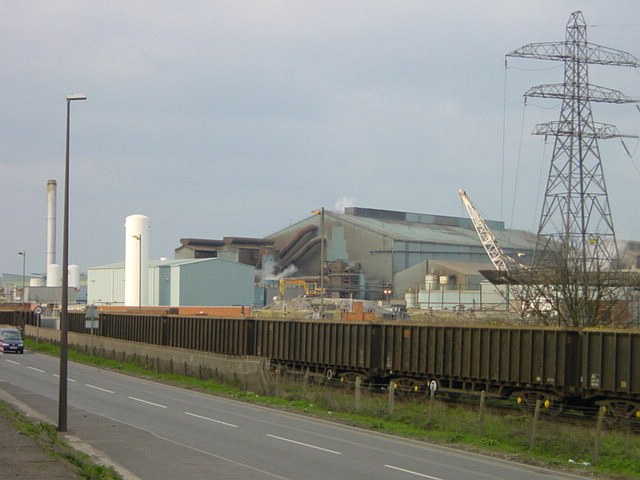
Sheerness steel mill
The Port of Sheerness is a significant feature of the Isle of Sheppey's economy. Covering more than 1.5 million square metres,[32] it is one of the largest foreign car importers in the UK, and it handles thousands of tonnes of fruits and meat products from all over the world. Inexpensive land and good infrastructure, including a rail network that branches off the main passenger line, have attracted industries to the port area, including producers of pharmaceuticals, steel, sausages and garden gnomes.[33] The major employers are HBC Engineering Solutions, Sheerness Steel, Regis Furniture and The Bond Group - although HBC has closed and the Steel plant is currently closed but may reopen.[34] The steel mill was established in 1972, designed to recycle scrap steel into rods and coils. It has survived a number of closure threats and changes of ownership, although it went into administration in January 2012. Since 2003 it has been operated by Thamesteel.[35] Unfortunately due to the economic downturn, Thamesteel went into administration in June 2012, with the loss of 350 jobs which dramatically impacted upon the islands economy. The seafront is popular with tourists, and as of 2007 Sheerness' recently refurbished town centre had more than 200 shops.[36]
As of the 2001 UK census, 35.8% of residents aged 16–74 were employed full-time, 11.6% part-time, 5.8% self-employed and 6.2% unemployed, while 1.5% were students with jobs, 3.4% students without jobs, 11.9% retired, 10.6% looking after home or family, 8.5% permanently sick or disabled and 4.8% economically inactive for other reasons. The unemployment rate of 6.2% was high compared to the national rate of 3.4% and was the highest rate throughout the Swale district. Five percent of Sheerness residents aged 16–74 had a higher education qualification compared to 20% nationally.[37] Employment by industry was 22% manufacturing; 18% retail; 10% construction; 10% transport and communications; 9% real estate; 8% health and social work; 6% public administration; 5% education; 5% hotels and restaurants; 1% finance; 1% agriculture; 1% energy and water supply; and 4% other community, social or personal services. Compared to national figures, Sheerness had a relatively high percentage of workers in manufacturing, transport and communications, and a relatively low percentage in agriculture, hotels, restaurants, education, health, social work and finance.[37]
As of the 2001 UK census, 4,292 of the town's residents were employed and there were 5,532 jobs within the town.[37] According to Office for National Statistics estimates, the average gross weekly income of households in Sheerness from April 2001 to March 2002 was £385 (£20,075 per year).[37]
Culture[]


Garrison point seen from the Isle of Grain
Sheerness' sand and shingle beach was awarded a European Blue Flag for cleanliness and safety. Flower gardens decorate the seafront, and a sea wall forms a promenade along the coast. The Sheppey Leisure Complex located near the beach contains a swimming pool and badminton, squash and tennis courts.[38] Other sports clubs include Sheerness Town Bowls Club, Sheerness East Cricket Club, the Isle of Sheppey Sailing Club, Beachfields Skatepark, Sheerness East Table Tennis Club, Catamaran Yacht Club, and Sheerness Swimming Club and Lifeguard Corps.[39] Sheerness Golf Club was founded in 1906, and has an 18-hole course just to the south-east of town.[40] Sheerness East Football Club, established in 1932, play in the Kent County League Premier Division. Sports can be played for free at the town's recreation grounds at Beachfields Park, Festival Playing Field, and Seager Road Sports Ground.[41] In 2005, 2006 & 2007 Sheppey Big Fish Arts organised Annual SeaSheppey Festivals in Blue Town and Queenborough Funded by the Heritage Lottery fund to celebrate Sheppey's unique Maritime history The annual Sheerness arts and heritage festival, Promenade, opened in September 2011 with appearances by Michael Palin and Dan Cruickshank. It is the only heritage festival on the Isle of Sheppey and takes place in September in The Sheppey Little Theatre, the Heritage Center in Blue Town and various other venues in Sheerness.
Sheerness has a library and clubs for photography, music, singing, dancing and writing.[42] Sheerness' town centre is home to the largest freestanding cast iron clock tower in Kent. It is 36 feet (11 m) tall and was built in 1902 at a cost of around £360 to commemorate the coronation of King Edward VII. In 2002, the clock tower was restored to celebrate the Golden Jubilee of Queen Elizabeth II.[43] and then again in 2012 to celebrate the Diamond Jubilee.
Media[]
The Sheerness Times Guardian is now the only newspaper serving the town and island at large, owned by the KM Group. The Sheppey Gazette recently closed after around 100 years of publication. It was owned by Northcliffe Media. The Island has its own radio station, BRFM 95.6 FM is Community Radio Station, which can also be heard online at www.brfm.net that broadcasts 24 hours a day, 7 days a Week from Minster-on-Sea. BRFM in October 2011 was granted a 5-year extension to its broadcast licence by regulator Ofcom and will remain broadcasting to Swale until 2016. The station is run by a dedicated team of 20 volunteers. BRFM 95.6 plays a wide range of music, with news, weather and local events being broadcast around the clock, the station also provides for specialist music during weekday evenings.[44]
In July 2013 the island received some notoriety for an attack on a tour bus of Jewish boys by local youths who shouted epithets, and threw stones and eggs, telling the boys to "go back to where you came from!"[45]
Transport[]

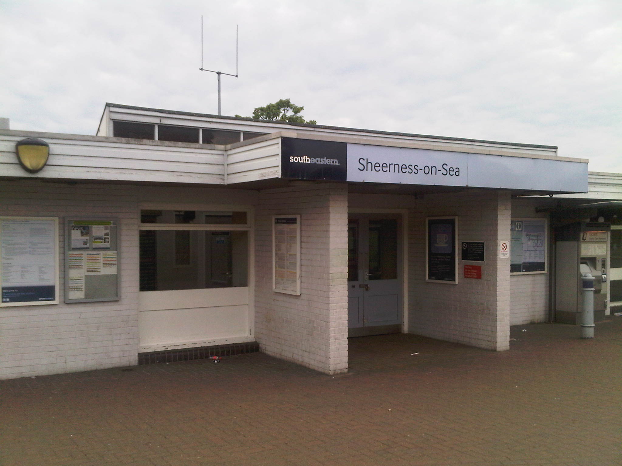
Exterior of the railway station in Sheerness-on-Sea (2011)
Sheerness-on-Sea railway station is on the Sheerness Line, run by the Southeastern rail company. The line connects Sheerness with the town of Sittingbourne, 6 miles (10 km) south on the mainland of Kent. Sittingbourne is on the Chatham Main Line, which connects London with Ramsgate and Dover in East Kent. Train journeys from Sheerness-on-Sea to London Victoria take 1 hour 45 minutes.[46]
The Arriva transport company operates bus routes reaching most of the island, as well as Sittingbourne, Maidstone, and Canterbury[47] Arriva Bus company use several routes, including 334, 341, 361, 360, 362, 363 and special day trips to Bluewater Shopping Centre, Hempstead Valley, Pentagon in Chatham, Maidstone Market and Lakeside Shopping Centre. Chalkwell Bus & Coach Company also serve Sheerness and the local area, going from Sheerness to Warden Bay via Minster-On-Sheppey. The A249 road terminates at Sheerness, running from Maidstone via Sittingbourne. The road crosses the M2 motorway near Sittingbourne, and the M20 motorway near Maidstone.[48] No passenger ferry services currently operate from Sheerness, although in the past there has been a service to Vlissingen in the Netherlands.
Coach Link (part of the Kingsferry Coach Company) also provide service from Sheerness, Minster, Halfway, Queenborough and part of the mainland to London Victoria Rail Station early in the morning and a return journey in the evening. Three school buses run from the Isle Of Sheppey to Sittingbourne school in the morning and after school finishes.
Education[]
Until September 2009, The Isle of Sheppey was the only area in Kent to still have a middle school system.[49] On the island, primary schools taught pupils from ages 4–9, middle schools from ages 9–13 and secondary schools from ages 13–18. Minster College in the neighbouring town of Minster was the only secondary school on the island. Sheerness had one middle school, Isle of sheppey Academy, with 800 pupils, although Danley Middle School and St George's Middle School were found in Halfway and Minster, respectively. In 2006, the Cheyne Middle School's Key Stage 2 performance ranked 322nd out of Kent's 386 primary and middle schools.[50] The town's primary schools are Richmond First School, Rose Street Primary School, St Edward's Roman Catholic Primary School (ages 4–11) and West Minster Primary School.[51] Sheppey College, in Sheerness, is a branch of Canterbury College that provides a range of further education courses.[52]
On 1 September 2009, Cheyne Middle school and Minster College merged to become The Isle of Sheppey Academy. Danley Middle school close and St George's Middle School changed into a primary school with a £3m fund, and Richmond First School now houses an extra year of students. This change was to bring the Island up to date with the rest of the UK with the two-tier system (Primary school, and then secondary school). Respectively, The Isle of Sheppey Academy now ranges from students of year 6 - 11, as well as housing the Island's 6th form students.[53]
For a while nobody was sure whether or not the plans for the Academy would go ahead, after the news that the current Government was scrapping Labour's 'Building Schools for the Future' scheme. For weeks Students, Teachers and Staff and Parents waited to hear whether or not the Academy would be built, and after much pressure on the Government from our local MP Gordon Henderson, it was announced that the Academy would receive the full £56 million funding and the go-ahead for all building to take place. Building for the Isle of Sheppey Academy is now expected to start within the first few months of 2011. Building was then completed in January 2013. At present there are currently 7 primary schools on the Isle of Sheppey: Queenborough First School; Richmond Primary School, Rose Street Primary School and Westminster Primary School (both part of the Sheerness West Federation), Minster Primary School, St George's Primary School and Eastchurch Primary School (Split over two sites, one in Eastchurch the other in Leysdown).
Tales of Beachfields Park[]
Beachfields Park provided a green oasis between the town of Sheerness and the sea. However, this has been systematically encroached on by development. This project is aiming to reveal and publicise the Park's heritage and to preserve it for future generations.
Past pupils of Cheyne Middle School and Minster College with further assistance from Groundwork Medway Swale and the Local Heritage Initiative, researched the funfair, bandstands, Prisoner of the War hut, boating lake and bowling green. The pupils created questionnaires and have interviewed many local residents. The Local History Society, the Sheerness Society and The Sheerness Times Guardian were all actively involved in the project.
The pupils and students have also written an award winning book to accompany the project. Tales of Beachfields Park has been awarded the Historical Association Young Historian Primary School Award for Local History.
Grants:
- Heritage Lottery Fund: £7,214
- Nationwide Building Society: £500[54]
References[]
- ↑ The diaries of Samuel Pepys from London, UK in the 17th century
- ↑ 2.0 2.1 2.2 2.3 2.4 2.5 "History". Sheppey Access. http://www.clcshe.eclipse.co.uk/history.html. Retrieved 2007-04-29.
- ↑ 3.0 3.1 "1958: Historic Sheerness docks to close". BBC. 1958-02-20. http://news.bbc.co.uk/onthisday/hi/dates/stories/february/20/newsid_2552000/2552135.stm. Retrieved 2007-04-29.
- ↑ Sheerness Dockyard's entry on the Buildings at Risk register.
- ↑ "The Nore". The Columbia Encyclopedia. 2006. Archived from the original on 2011-05-16. http://web.archive.org/web/20110516191220/http://www.highbeam.com/doc/1E1-Nore.html. Retrieved 2007-04-29.
- ↑ "Mutiny". The Columbia Encyclopedia. 2006. Archived from the original on 2011-05-16. http://web.archive.org/web/20110516191232/http://www.highbeam.com/doc/1E1-mutiny.html. Retrieved 2007-04-29.
- ↑ "A vision of Minster in Sheppey AP/CP". VisionOfBritain.org.uk. http://www.visionofbritain.org.uk/unit_page.jsp?u_id=10223015. Retrieved 2007-07-22.
- ↑ "Origins of Cooperation". Laurel Net Cooperative. 1999. Archived from the original on 25 January 2008. http://web.archive.org/web/20080125093602/http://uts.cc.utexas.edu/~laurel/cooproots/origins.html. Retrieved 2007-04-29.
- ↑ 9.0 9.1 "The first co-op". SheernessHeritageCentre.com. 2006. http://www.sheernessheritagecentre.com/page6sheernesscoop.htm. Retrieved 2007-04-29.
- ↑ 10.0 10.1 "Sheerness". MaritimeHeritageTrail.co.uk. http://www.maritimeheritagetrail.co.uk/EN/loc_history.php?id=8&page=1. Retrieved 2007-04-29.[dead link]
- ↑ 11.0 11.1 "Relationships / unit history of Sheerness". VisionOfBritain.org.uk. http://www.visionofbritain.org.uk/relationships.jsp?u_id=10225449&c_id=10001043. Retrieved 2007-07-22. Cite error: Invalid
<ref>tag; name "relationsheer" defined multiple times with different content - ↑ "Sheppey Light Railway". HFStephens-Museum.org.uk. Archived from the original on 24 April 2007. http://web.archive.org/web/20070424141524/http://hfstephens-museum.org.uk/pages/his_railways/sheppey.htm. Retrieved 2007-04-29.
- ↑ "Chronology of Sheerness in the lifetime of the Sheerness Heritage Centre". SheernessHeritageCentre.com. Archived from the original on 2007-02-13. http://web.archive.org/web/20070213210637/http://www.sheernessheritagecentre.com/page2chronology.htm. Retrieved 2007-04-29.
- ↑ "Time Bomb Ready to Blow". Evening Standard. 2004-08-19. http://www.thisislondon.co.uk/news/article-12667880-details/Timebomb+ready+to+blow/article.do. Retrieved 2007-04-29.[dead link]
- ↑ Press release
- ↑ Coles Finch, William (1933). Watermills and Windmills. London: C W Daniel Company. pp. 275–77.
- ↑ "Fire rips through town's windmill". BBC News Online. 2008-01-24. http://news.bbc.co.uk/1/hi/england/kent/7207555.stm. Retrieved 2008-04-22.
- ↑ "Arson attack on Sheerness windmill ruled out". Kent News. http://www.kentnews.co.uk/kent-news/Sheerness-windmill-gutted-in-mystery-fire-newsinkent9144.aspx?news=local. Retrieved 2008-04-22.[dead link]
- ↑ Farries, K G, and Mason, M T (1966). The Windmills of Surrey and Inner London. London: Charles Skilton Ltd.. pp. 51.
- ↑ "Derek Wyatt". Guardian.co.uk. http://politics.guardian.co.uk/person/0,9290,-5704,00.html. Retrieved 2007-04-29.
- ↑ "List Councillors By Ward". Swale Borough Council. http://www.swale.gov.uk/dso/CouncillorsBy.asp?SortOrder=Ward. Retrieved 2007-03-29.
- ↑ 22.0 22.1 "Swale Borough Council's Expenditure". Swale Borough Council. Archived from the original on 27 September 2007. http://web.archive.org/web/20070927063908/http://www.swale.gov.uk/index.cfm?articleid=1551. Retrieved 2007-03-29.
- ↑ A vision of Britain through time. "A vision of Sheerness UD". visionofbritain.org.uk. http://www.visionofbritain.org.uk/unit_page.jsp?u_id=10135515. Retrieved 2007-08-17.
- ↑ Laurence Black. "Faversham Labour Party 1918–1994" (PDF). London Guildhall University. http://www.microform.co.uk/guides/R97563.pdf. Retrieved 2007-03-29.
- ↑ Sheppey Access local website for residents and visitors
- ↑ Woodward, Horrace B (1904). Stanford's Geological Atlas.
- ↑ "Nature On The Map". Natural England. http://www.natureonthemap.org.uk/map.aspx?m=nreserves. Retrieved 2007-04-30.
- ↑ 28.0 28.1 "1971-2000 mapped averages". Met Office. Archived from the original on 22 April 2007. http://web.archive.org/web/20070422202137/http://www.metoffice.gov.uk/climate/uk/averages/19712000/mapped.html. Retrieved 2007-04-29. Cite error: Invalid
<ref>tag; name "mapped" defined multiple times with different content - ↑ "Area: Sheerness East (Ward)". Statistics.gov.uk. http://neighbourhood.statistics.gov.uk/dissemination/LeadDomainList.do?a=3&c=sheern&d=14&i=1001x1002&m=0&enc=1&areaId=5945236&OAAreaId=459915. Retrieved 2007-03-29.
- ↑ "Area: Sheerness West (Ward)". Statistics.gov.uk. http://neighbourhood.statistics.gov.uk/dissemination/LeadDomainList.do?a=3&c=sheern&d=14&i=1001x1002&m=0&enc=1&areaId=5945235&OAAreaId=459934. Retrieved 2007-03-29.
- ↑ "2005 – Population Estimates by Ward". Swale Borough Council. Archived from the original on 27 September 2007. http://web.archive.org/web/20070927063953/http://www.swale.gov.uk/index.cfm?articleid=4477. Retrieved 2007-07-02.
- ↑ "Port of Sheerness". Swale Borough Council. Archived from the original on 27 September 2007. http://web.archive.org/web/20070927064050/http://www.swale.gov.uk/index.cfm?articleid=1406. Retrieved 2007-04-29.
- ↑ "An Introduction to the Isle of Sheppey". Sheppey Access. http://www.clcshe.eclipse.co.uk/. Retrieved 2007-04-29.
- ↑ "Sheerness". Swale Borough Council. Archived from the original on 27 September 2007. http://web.archive.org/web/20070927064029/http://www.swale.gov.uk/index.cfm?articleid=1407. Retrieved 2007-04-29.
- ↑ Thamesteel website
- ↑ "Sheerness Town Centre". Swale Borough Council. Archived from the original on 27 September 2007. http://web.archive.org/web/20070927064008/http://www.swale.gov.uk/index.cfm?articleid=1438. Retrieved 2007-04-29.
- ↑ 37.0 37.1 37.2 37.3 "Neighbourhood Statistics". Statistics.gov.uk. http://neighbourhood.statistics.gov.uk/dissemination/LeadHome.do;jsessionid=ac1f930bce6a711447e60ba4446bb56c21648d42c51.e38PbNqOa3qRe38OaNeKahqMai1ynknvrkLOlQzNp65In0?bhcp=1. Retrieved 2007-03-29.
- ↑ "Sheppey Leisure Complex". Swale Borough Council. Archived from the original on 27 September 2007. http://web.archive.org/web/20070927063844/http://www.swale.gov.uk/index.cfm?articleid=1532. Retrieved 2007-04-29.
- ↑ "Sports Directory". Swale Borough Council. Archived from the original on 2 December 2006. http://web.archive.org/web/20061202173645/http://www.swale.gov.uk/index.cfm?articleid=3803. Retrieved 2007-04-29.
- ↑ "Sheerness Golf Club". EnglishGolf-Courses.co.uk. http://www.englishgolf-courses.co.uk/kent/sheerness.php. Retrieved 2007-04-29.
- ↑ "Parks and Open Spaces". Swale Borough Council. Archived from the original on 26 January 2008. http://web.archive.org/web/20080126074844/http://www.swale.gov.uk/index.cfm?articleid=3017. Retrieved 2007-04-29.
- ↑ "Clubs and Societies". Swale Borough Council. Archived from the original on 26 January 2008. http://web.archive.org/web/20080126074849/http://www.swale.gov.uk/index.cfm?articleid=3472. Retrieved 2007-04-29.
- ↑ "Culture". Sheppey Access. http://www.clcshe.eclipse.co.uk/. Retrieved 2007-04-29.
- ↑ "BRFM 95.6 FM". MediaUK.com. http://www.mediauk.com/radio/343729/brfm-95.6-fm. Retrieved 2007-04-14.
- ↑ http://www.kentonline.co.uk/times_guardian/news/jewish-attack-3853/
- ↑ "Southeastern Railway". Southeastern Railway. http://www.southeasternrailway.co.uk/. Retrieved 2007-04-29.
- ↑ "Sheerness services". Arriva. http://www.arrivabus.co.uk/__80256E280053B5B6.nsf/vWeb/pcCWAN5XFEHA?open®ion=Southern%20Counties&town=Sheerness&service=. Retrieved 2007-04-29.
- ↑ "Google maps". Google. http://maps.google.com/maps?ll=51.441,0.7605&spn=0.1,0.1&q=51.441,0.7605. Retrieved 2007-04-29.
- ↑ "Public school may sponsor academy". BBC. 2005-02-18. http://news.bbc.co.uk/1/hi/england/kent/4277213.stm. Retrieved 2007-04-15.
- ↑ "Primary schools in Kent". BBC. 2006-12-07. http://news.bbc.co.uk/1/shared/bsp/hi/education/06/school_tables/primary_schools/html/agg_886.stm. Retrieved 2007-04-29.
- ↑ "UK Schools and Colleges Database". Schoolswebdirectory.co.uk. http://www.schoolswebdirectory.co.uk/postcode.php?searchword=me12&action=Search. Retrieved 2007-04-29.
- ↑ "Useful contacts". Sheerness.Surestart.org. Archived from the original on 2007-02-03. http://web.archive.org/web/20070203191701/http://sheerness.surestart.org/index.php?page_id=23. Retrieved 2007-04-29.
- ↑ Image of closed Danley Middle School Web Site. Accessed 2010-07-11
- ↑ "Tales of Beachfields Park". Local Heritage Initiative. http://www.lhi.org.uk/projects_directory/projects_by_region/south_east/kent/tales_of_beachfields_park/index.html. Retrieved 2008-13-13.
Further reading[]
- Tales Of Beachfields Park, (2003), Winner of the 2003 Historical Association Young Historian Primary School Award for Local History
- Sheerness and the mutiny at the Nore, (1997), ISBN 0-9530665-0-9
- Branch lines around Sheerness, (1993), ISBN 1-873793-16-2
External links[]
| Wikimedia Commons has media related to Sheerness. |
The original article can be found at Sheerness and the edit history here.