| Scribner State Airport Scribner Army Airfield | |||
|---|---|---|---|
| |||
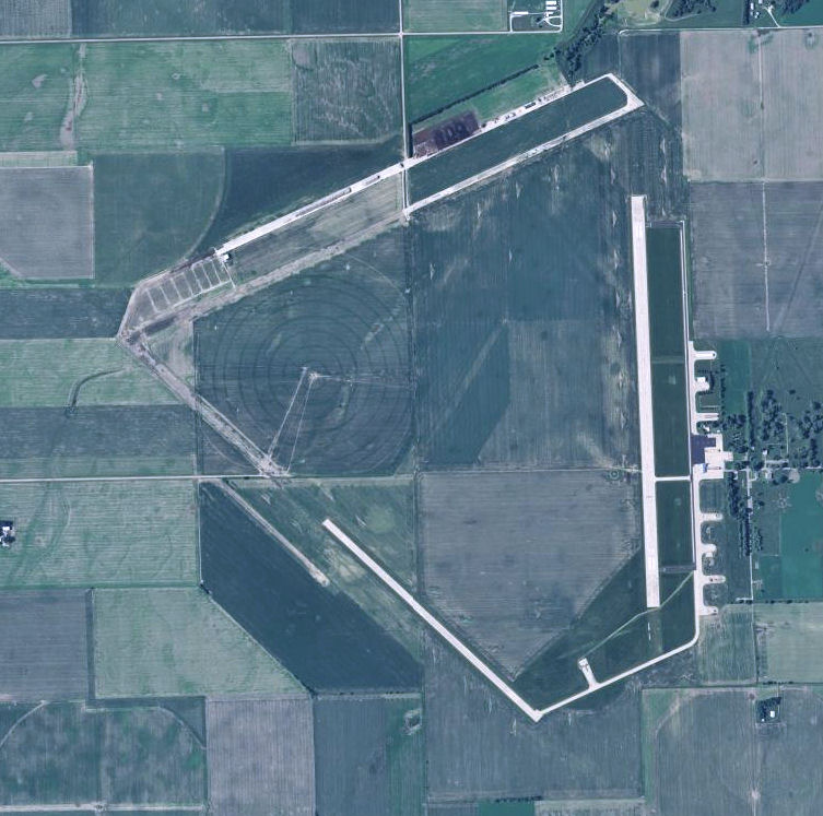
| 2006 USGS Orthophoto | |||
| IATA: SCB – ICAO: KSCB – FAA LID: SCB | |||
| Summary | |||
| Airport type | Public | ||
| Owner | Nebraska Dept of Aeronautics | ||
| Serves | Scribner, Nebraska | ||
| Location | Everett Township, Dodge County, near Scribner, Nebraska | ||
| Elevation AMSL | 1,325 ft / 404 m | ||
| Coordinates | 41°36′37″N 096°37′48″W / 41.61028°N 96.63°W | ||
| Map | |||
 KSCB | |||
| Runways | |||
| Direction | Length | Surface | |
| ft | m | ||
| 17/35 | 4,200 | 1,280 | Concrete |
| 12/30 | 3,199 | 975 | Concrete |
| Statistics (2007) | |||
| Aircraft operations | 2,600 | ||
| Based aircraft | 21 | ||
| Source: Federal Aviation Administration[1] | |||
Scribner State Airport (IATA: SCB, ICAO: KSCB, FAA Location identifier: SCB) is a public use airport located three nautical miles (6 km) southeast of the central business district of Scribner, a city in Dodge County, Nebraska, United States. It is owned by the Nebraska Department of Aeronautics.[1]
Facilities and aircraft[]
Scribner State Airport covers an area of 789 acres (319 ha) at an elevation of 1,325 feet (404 m) above mean sea level. It has two runways with concrete surfaces: 17/35 is 4,200 by 75 feet (1,280 x 23 m) and 12/30 is 3,199 by 60 feet (975 x 18 m).[1]
For the 12-month period ending August 22, 2007, the airport had 2,600 aircraft operations, an average of 216 per month: 96% general aviation and 4% military. At that time there were 21 aircraft based at this airport: 67% single-engine and 33% ultralight.[1]
History[]
Scribner State Airport was constructed in 1942 as a United States Army Air Forces military training airfield. The 2,060-acre (8.3 km2) site is located south of the Elkhorn River and is surrounded by low rolling hills on the east, north and west. Agriculture is the main industry of the area.
The first official news that Scribner Army Airfield would be constructed came on 1 October 1942, with eviction notices given to area farmers shortly thereafter. Construction soon began, with two runways completed by 26 November 1942. 87 buildings and structures were constructed. The base was officially opened on 9 December 1942.[2]
Scribner AAF was one of eleven training airfields in Nebraska, and came under the command of Second Air Force. It was initially designated as a satellite base to Sioux City Army Air Base, Iowa, though by 1943 it became an independent base, with Ainsworth Army Airfield, Nebraska, being designated as Scribner's satellite. The 4316th Army Air Force Base Unit had host unit responsibilities at Schribner. In December 1942, the Base Commander was Major A. J. Guffanti.[3][4]
The field's primary mission was to provide aircrew training for B-17 Flying Fortress and B-24 Liberator bomber air crews. In addition, P-47 Thunderbolt fighter pilots completed proficiency training at Scribner before reassignment to the European Theater of Operations. Crews that used Scribner Army Airfield included the following:[5][6]
- 583rd Bombardment Squadron (3 July-1 August 1943) (B-17 Flying Fortress)
- Component of: 383d Bombardment Group, assigned to Geiger Field, Washington
- Provided Operational Training at Schribner.
- 36th Fighter Group (November 1943-March 1944)
- 22nd, 23rd, and 53rd Fighter Squadrons (P-47 Thunderbolt)
- Deployed to Ninth Air Force in England
Schribner also became a camouflage school. By 1943 the entire airfield was camouflaged to look like a farm and small village to prove that an airfield could be hidden from the enemy. The hangar was painted red to resemble a barn, chicken wire was stuffed with green colored spun glass to resemble trees, and a mock silo beside the barn really housed the sliding hangar doors. Another building was given a steeple and painted to resemble a church, and a "school house" was built with spun-glass children. Even the runways were coated with tar and coated with wood chips and ground corncobs, and painted green or brown, depending on the season.
The USAAF training airfield closed on 31 December 1945 and the State of Nebraska acquired the Airfield property from the U.S. Government in 1946. By 1951, word came that the then surplus Scribner Air Base was being considered as the site of a proposed United States Air Force Academy. This did not happen, however, the U.S. Air Force acquired 136 acres (0.55 km2) for installation of an ionosphere sounding station. This High Frequency radio receiver site did operate and is in fact still in operation as an unmanned annex of Offutt AFB. During this same era, some of the old WW-II era temporary barracks and administrative facilities, located near the HF receiver site, was known as "Site-X"—an emergency relocation site for Headquarters, Strategic Air Command at Offutt AFB, in use until SAC's underground command post at Offutt became operational. The detachment operated until 30 April 1959, when it was discontinued.[7] [8]
The remainder of the former Airfield was rented out. Nebraska Department of Aeronautics continues to operate the airfield, leasing storage and small segments of land to local concerns. A United States Air Force communications center is also located on the site.
Scribner State Airfield currently has two active runways. A few wartime buildings still are in use, along with the remains of the wartime runways.
See also[]
- Nebraska World War II Army Airfields
- List of airports in Nebraska
References[]
![]() This article incorporates public domain material from the Air Force Historical Research Agency website http://www.afhra.af.mil/.
This article incorporates public domain material from the Air Force Historical Research Agency website http://www.afhra.af.mil/.
- Maurer, Maurer (1983). Air Force Combat Units Of World War II. Maxwell AFB, Alabama: Office of Air Force History. ISBN 0-89201-092-4.
- ↑ 1.0 1.1 1.2 1.3 , effective 2009-05-07.
- ↑ Real-McKeighan, Tammy, "Pilots once trained at Scribner Air Base", Military Times, 4 September 2011.
- ↑ USAFHRA Document 00177633
- ↑ USAFHRA Document 00177637
- ↑ USAFHRA Document 00169028
- ↑ USAFHRA Document 00079524
- ↑ USAFHRA Document 00489538
- ↑ USAFHRA Document 00489563
External links[]
- Nebraska Motorplex
- FAA Terminal Procedures for SCB, effective April 18, 2024
- Resources for this airport:
- FAA airport information for SCB
- AirNav airport information for SCB
- ASN accident history for SCB
- FlightAware airport information and live flight tracker
- SkyVector aeronautical chart for SCB
The original article can be found at Scribner State Airport and the edit history here.