| Province of Leyte Lalawigan han Leyte Lalawigan ng Leyte | |||
|---|---|---|---|
| Province | |||
| Province of Leyte | |||
| |||
| Coordinates: 11°00′N 124°51′E / 11°N 124.85°ECoordinates: 11°00′N 124°51′E / 11°N 124.85°E | |||
| Country |
| ||
| Region | Eastern Visayas (Region VIII) | ||
| Founded | 1735[1] | ||
| Capital | Tacloban City | ||
| Government | |||
| • Governor | Dominico Petilla (LP) | ||
| • Vice Governor | Carlo Loreto (LP) | ||
| Area[2] | |||
| • Total | 6,313.33 km2 (2,400 sq mi) | ||
| Area rank | 14th out of 80 | ||
| Excludes Tacloban City | |||
| Population (2010)[3] | |||
| • Total | 1,567,984 | ||
| • Rank | 15th out of 80 | ||
| • Density | 250/km2 (640/sq mi) | ||
| • Density rank | 31st out of 80 | ||
| Excludes Tacloban City | |||
| Divisions | |||
| • Independent cities | 2 | ||
| • Component cities | 1 | ||
| • Municipalities | 41 | ||
| • Barangays |
1,393 including independent cities: 1,641 | ||
| • Districts | 1st to 5th districts of Leyte (shared with Ormoc and Tacloban cities) | ||
| Time zone | PHT (UTC+8) | ||
| ZIP Code | 6500 - 6542 | ||
| Dialing code | 53 | ||
| Spoken languages | Waray-Waray, Cebuano, Filipino, English | ||
| Website | www.leyte.org.ph | ||
Leyte (also Northern Leyte; Filipino: Hilagang Leyte) is a province of the Philippines located in the Eastern Visayas region. Its capital is Tacloban City and occupies the northern three-quarters of the Leyte Island. Leyte is located west of Samar Island, north of Southern Leyte and south of Biliran. To the west of Leyte across the Camotes Sea is Cebu Province.
History[]
The explorer Ruy López de Villalobos, first came to the island in 1543 and named it Las Islas Felipinas.
Battle of Leyte Gulf[]
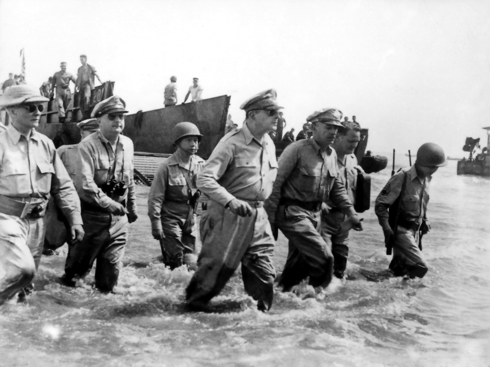
When Americans stormed ashore at Leyte, it fulfilled a promise to return made by Gen. Douglas MacArthur made in the days following the fall of the Philippines to the Japanese in 1942.
During World War II under the Japanese Occupation, the 9th and 92nd Infantry Division of the Philippine Commonwealth Army was reestablished from 1942 to 1946 at the military general headquarters and military camps and garrisoned in Tacloban and Ormoc before the liberation of the Philippines was the military unit organization and started by the Anti-Japanese military operations in the province of Leyte from 1942 to 1945 to helping the local guerrilla groups under by Colonel Ruperto Kangleon and the American liberating forces and fought against the Japanese Imperial forces.
The Battle of Leyte Gulf took place in the seas surrounding this island from 23 October to 26 October 1944. It was the largest naval battle in modern history, when at least 212 Allied ships clashed with the remnants of the Imperial Japanese Navy, some 60 ships, including the super battleships Yamato and Musashi.
The First Battle of Leyte occurred on 20 October 1944. A successful Allied invasion of the island was the crucial element to the eventual Filipino and American victory in the Philippines.
Proposed Division of Leyte[]
In March 27, 1923, Act No. 3117 proposed to divide Leyte into Occidental Leyte and Oriental Leyte but was not proclaimed by the Governor-General of the Philippines.
Political divisions[]


Political map of Leyte
Leyte is subdivided into 41 municipalities and three cities. The municipalities are clustered into 5 congressional districts.
Ormoc City is an independent component city, while the capital Tacloban was declared a highly-urbanized city in 2008. Both cities govern themselves independently of the province and their residents do not vote for elective provincial officials. Baybay attained cityhood in 2007 but reverted to its municipal status when the Supreme Court declared its city charter unconstitutional in 2008; however, Baybay would regain its city status following the reversal of the Supreme Court decision dated December 22, 2009. But on August 2010 a resolution has been passed striking down the 16 cities, since Baybay is part of the cities, it was not a city anymore. But, on February 15, 2011 Baybay is a city once again. The Supreme Court reversed its decision once again and Baybay now is a city.[4]
Highly urbanized city[]
- Tacloban
Component city[]
- Baybay
Independent component city[]
- Ormoc
Municipalities[]
Demographics[]
| Population census of Leyte | ||
|---|---|---|
| 1990.3315 | 1,230,925 | — |
| 1995.6685 | 1,343,941 | 1.77% |
| 2000.3333 | 1,413,697 | 1.02% |
| 2007.5836 | 1,506,096 | 0.91% |
| 2010.3315 | 1,567,984 | 1.35% |
| Excluding Tacloban City Source: National Statistics Office[3] | ||
The people of Leyte are divided into two main groups, primarily by language. In the west and south are the Cebuanos, while in the north and east is the Waray-Waray (Leyte dialect).
There are also some Spanish mestizos and some natives of the province who can understand and speak Spanish due to the province's colonial history.
According to the Year 2000 census, 97% of Leyte's population is Roman Catholics, one of the highest percentage in the Visayas. While the remaining 3% are either adherents of other different Christian sects such as the indigenous Baptists, Evangelicals, Mennonites, and Mormons, Christian.
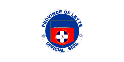
Official Provincial Seal[]


Leyte Provincial Capitol - briefly became the seat of Philippine Commonwealth Government during the World War II era
The Official Seal of the Province of Leyte.
The upper portion is a perspective of the national Freedom Park commemorating the landing of General Douglas MacArthur and the American Liberation Forces in Leyte during World War II. The white cross represents the 2nd phase of Leyte's development when Magellan stopped here on his way to Cebu. The alphabet on the cross argent is the ancient Visayan paleographic syllabary of the letter L which stands for Leyte. The stars around the inner circle symbolize the forty-one (41) towns of Leyte and the everlasting flame symbolizes the soldiers who died during World War II.
Economy[]
The economy of Leyte is a mixed agriculture, fishing, industrial, energy and mining. Rice is farmed in the lowland plains areas specifically those around Tacloban, while coconut farming, is the main cash crop in upland and mountainous areas. Sugarcane plantation is no. 1 produce in Ormoc City. Since Leyte is an island province, fishing is a major source of livelihood among coastal residents.
The province is the site of the largest geothermal plant in Asia, making it one of the resource-rich provinces of the Philippines. Excess energy of the numerous powerplants in the geothermal valley that generate electricity is supplied to the national grid that adds to the energy demand in Luzon and Mindanao. Mining industry have started to pick up in the province with the exploration in MacArthur. The iron smelting in Isabel have been operational for more than 20 years since its inception.
Leyte ICT Park[]
The Leyte Information Communications Technology (ICT) Park is one of the economic zones approved by the Philippine Economic Zone Authority (PEZA).[5] Located at Pawing, Palo, Leyte, the 6.8 facility hosts two (2) business process outsourcing (BPO) companies, namely, the Expert Global Solutions (EGS) Company (formerly APAC Customer Services, Inc.) and ACUDATA, Inc. (a financial and data services BPO).
Leyte is emerging[according to whom?] to be an ICT-BPO Hub for Eastern Visayas.
Transportation[]
Leyte is connected by air, with only one commercial airport located in Tacloban City. Daniel Z. Romualdez Airport, which is one of the busiest aiports in the Philippines, has two major airlines; Philippine Airlines and Cebu Pacific. Tacloban's airport primarily serves connecting flights from major Philippine cities (Manila and Cebu).
Philtranco, which has a bus stop in Tacloban and Ormoc, operates a route along Manila-Maharlika highway, passing through Allen, Northern Samar in Samar Island (via ferry boat) from Matnog, Sorsogon in Bicol region.
Commercial seaport is of vital importance. Major ports of the province are located at Ormoc City,in the south and Tacloban City, in the north. Small ports are also located in Palompon, Hilongos and Baybay City.
See also[]
- Manuel Artigas
- Juan Ponce Sumuroy
References[]
- ↑ Archdiocese of Palo Accessed August 24, 2013
- ↑ "List of Provinces". Makati City, Philippines. http://www.nscb.gov.ph/activestats/psgc/listprov.asp. Retrieved 12 June 2013.
- ↑ 3.0 3.1 "Population and Annual Growth Rates for The Philippines and Its Regions, Provinces, and Highly Urbanized Cities". 2010 Census and Housing Population. National Statistics Office. http://www.census.gov.ph/sites/default/files/attachments/hsd/pressrelease/Population%20and%20Annual%20Growth%20Rates%20for%20The%20Philippines%20and%20Its%20Regions%2C%20Provinces%2C%20and%20Highly%20Urbanized%20Cities%20Based%20on%201990%2C%202000%2C%20and%202010%20Censuses.pdf. Retrieved 12 June 2013.
- ↑ SC reverses self, upholds creation of 16 cities
- ↑ http://www.peza.gov.ph/index.php?option=com_content&view=article&id=116&Itemid=161&nature=IT%20Parks/Centers
External links[]
| Wikimedia Commons has media related to Leyte. |
- Official Website of Leyte Province
- Inquirer.net, Poor town has modern library
- 2007 Philippine Census Information
- Local Governance Performance Management System
 |
Masbate / Samar Sea | Biliran | San Juanico Strait / Samar |
|
| Cebu / Camotes Sea | Leyte Gulf | |||
| ||||
| Bohol / Camotes Sea | Southern Leyte |
The original article can be found at Leyte and the edit history here.