| R | |
|---|---|
 Location of R in
[[file:Template:Location map data|240px|Ranthambore Fort is located in Template:Location map data]]<div style="position: absolute; top: Expression error: Unrecognized punctuation character "[".%; left: Expression error: Unrecognized punctuation character "[".%; height: 0; width: 0; margin: 0; padding: 0;"><div style="position: relative; text-align: center; left: -Expression error: Unrecognized punctuation character "[".px; top: -Expression error: Unrecognized punctuation character "[".px; width: Template:Location map datapx; font-size: Template:Location map datapx; line-height: 0;" title="">[[File:Template:Location map data|Template:Location map dataxTemplate:Location map datapx|Ranthambore Fort|link=|alt=]] <div style="font-size: 90%; line-height: 110%; position: relative; top: -1.5em; width: 6em; Expression error: Unrecognized punctuation character "[".">Ranthambore Fort (Template:Location map data)
| |
| Location | Sawai Madhopur, Rajasthan |
| Coordinates | 26°01′02″N 76°30′09″E / 26.01733°N 76.50257°ECoordinates: 26°01′02″N 76°30′09″E / 26.01733°N 76.50257°E |
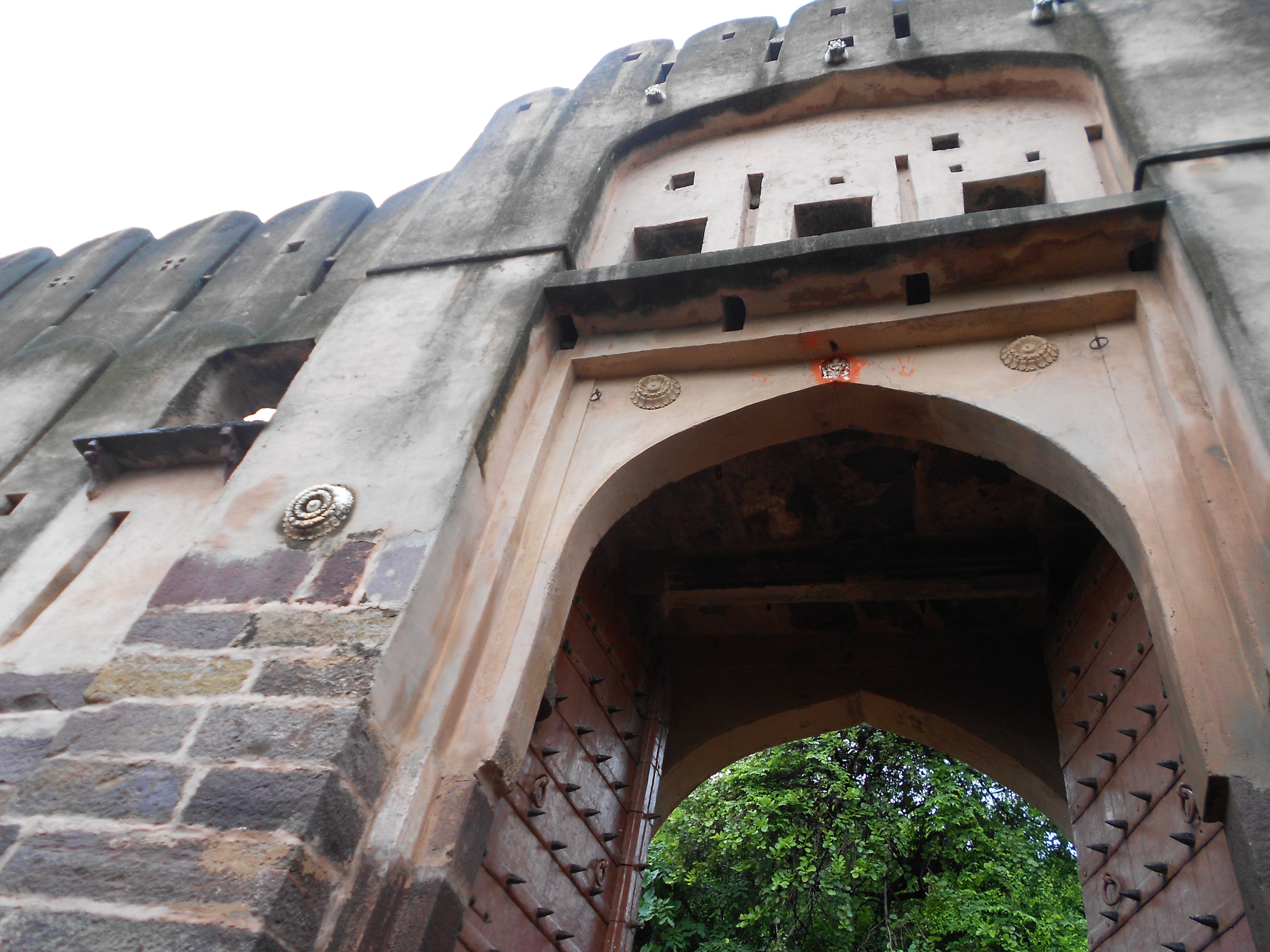
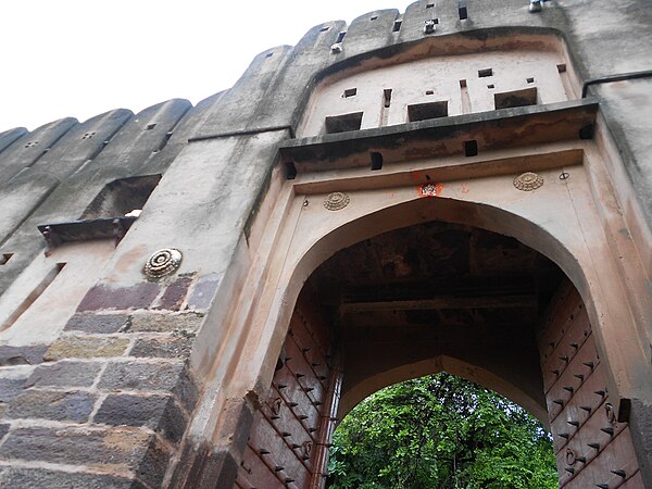
Ranthambore Fort (Hindi:रणथम्भोर) is part of the World Heritage Site Hill Forts of Rajasthan.[1] situated near Sawai Madhopur town in Rajasthan. It is formidable fort and has been a focal point of historical developments of Rajasthan. This fort is known for the glory and valor of brave Hammir dev of Chauhan dynasty.
The fort lies within the Ranthambore National Park which was formerly the hunting grounds for the Maharajahs of Jaipur before Indian independence.
History[]
Ancient history[]
Its earlier name was Ranastambha (Hindi:रणस्तम्भ) or Ranastambhapura (Hindi:रणस्तम्भपुर). It was associated with Jainism during the reign of Prithviraja I of Chauhan dynasty in 12th century. Siddhasenasuri, who lived in 12th century has included this place in the list of holy Jaina tirthas. In Mughal period a temple of Mallinatha was built in the fort.[2]
The fortress of Ranthambore was founded in 944 by the Nagil Jats. The fortress commanded a strategic location, 700 feet above the surrounding plain. It is of historical importance to know about Nagil clan. Nagil people are descendants of Nagavanshi mahapurusha Nagavaloka (नागावलोक).[3][4][5]
Raja Sajraj Veer Singh Nagil (880 to 935 AD) was the most famous ruler of the this small Jat state who headed a small army of twenty thousand warriors including ten thousand cavalry to protect its kingdom from invaders. He was the first ruler of Ranthambore who developed and raised infrastructure to make this area suitable for defence.[6]
The Buddhist Bharhut stupa are supposed to be established by the Maurya king Ashoka in the 3rd century BCE. The inscriptions here mention about Nagil clan. Pillars of Railing on N.W. Quadrant in Bharhut bears an inscription which reads as under:
- Moragirihma Nāgilāyā bhikhuniya dānam thabho.
Meaning: " Pillar-gift of the Nun Nagila of Moragiri."[7]
Morgiri mentioned here is a town in Satara district, Maharashtra. Thus Nagil clan was in existence during Ashoka's period as followers of Buddhism.
They are also mentioned by Cunningham[8] in an inscription at the Buddhist Stupa of Sanchi of the Ashoka period as under:
- No. 181. — Bhadata Nāgilasa Savamamjnātinam dānam thabho.
- Meaning " Pillar-gift of Bhadrata Nagila, the learned in all things."
Prinsep, No. 47, reads Danda-nagilalasa pavinanātinam dānathambho ; and translates, " This pillar is the gift of the illustrious family of Danda Nagirala."
Tej Ram Sharma[9] describes some names ending in la. He mentions from Udayagiri Cave Inscription of the time of Kumaragupta I of Gupta Year 106 (=A.D. 425) a name such as Samghila, who was a soldier who has been mentioned as an 'Ashvapaty. We find Agila (Agi Jat clan), Satila (Satalya Jat clan), Nagila (Nagil Jat clan), Yakhila (Jakha Jat clan), in Sanchi inscriptions.[10] Probably these indicate Jat clan names mentioned in brackets.
Thakur Deshraj[11] has mentioned the history of Nagil Jat clan. They trace their origin from Punjab. They were rulers in Ranthambore. The area around Ranthambore was ruled by Gora and Nagil jats till two centuries prior to the rule of Chauhans. According to the bards about twenty generations ruled here. Ranthambhor town was founded by Ran Mal Jat, hence the name Ranthambore. Ran Mal Jat founded this place by putting a stambh (pillar) at the location of present Ranthambore. He challenged the neighbouring rulers for battle. The Jat sardars of this area had helped Bhagabhatta Chauhan also against the Muslims. During Mughal period Jalaluddin Tuniya of Rajiya group wanted to become the ruler of the area. Rajiya also wanted to attack Ranthambore so asked for the help of Jats. When she was about to attack Ranthambore, a big group of Jats arrived with Gulam sardar Tuniya and she returned. Al-Tuniya with the help of Jat sardars, attacked Delhi.[12] Jats fought with bravery for this woman.[13][14]
Thakur Deshraj[15] mentions that in the ninth century one of their illustrious king named Nagavaloka ruled on the lands of Medapata. He ruled in democratic way through a system a council (rajasabha) and his capital was at Bijolia. The council used to award titles. A Chauhan chieftain named Guyak was awarded the title of 'Veer.[16]
After the defeat of the Chauhan king Prithvirajchauhan by Muhammad of Ghori in 1192, Ranthambore, led by Govinda Raja, grandson of Pritviraj, became the center of Chauhan resistance to the expanding Sultanate of Delhi. Govinda Raja was succeeded by his son Balhana.


1569-Akbar's entry into the fort of Ranthambhor
The Delhi Sultan Iltutmish captured Ranthambore in 1226, but the Chauhans recaptured it after his death in 1236. The armies of Sultan Nasir ud din Mahmud, led by the future Sultan Balban, unsuccessfully besieged the fortress in 1248 and 1253, but captured from Jaitrasingh Chauhan in 1259. shakti Dev succeeded Jaitrasingh in 1283, and recaptured Ranthambore and enlarged the kingdom. Sultan Jalal ud din Firuz Khilji briefly besieged the fort in 1290-91. In 1299, Hamir Dev sheltered Muhammad Shah, a rebel general of Sultan Ala ud din Khilji, and refused to turn him over to the Sultan. The sultan unsuccessfully besieged the fortress in 1299, but returned in 1301 to personally oversee a long siege, and succeeded in capturing the fort.
Modern history[]
The fortress was captured by the kingdom of Mewar under Rana Hamir Singh (1326–1364) and Rana Kumbha (1433–1468).[17][18][19] After the reign of Rana Kumbha's successor Rana Udai Singh I (1468–1473) the fortress passed to the Hada Rajputs of Bundi. Sultan Bahadur Shah of Gujarat captured the fortress from 1532 to 1535. The Mughal Emperor Akbar captured the fortress in 1559.
The fortress passed to the Kachwaha Maharajas of Jaipur in the 17th century, and it remained part of Jaipur state until Indian Independence. The area surrounding the fortress became a hunting ground for the Maharajas of Jaipur. Jaipur state acceded to India in 1949, becoming part of the state of Rajasthan in 1950.[20]
Inside Ranthambore fort there are three Hindu temples dedicated to Ganesh, Shiva and Ramlalaji constructed in 12th and 13th centuries from red Karauli stone. There is also a Jain temple of Lord Sumatinath (5th Jain Tirthankar) and Lord Sambhavanath.
Nearby attractions[]
Water Gateways
1.Kachida Valley
2.Surwal Lake
Picnic Sports
3.Malik Talao
Wild Life
4.Bakula
5.Lakarda And Anantpura
6.Rajbagh Talao
7.Ranthambhore Tiger Reserve Or National Park
Historical Places
8.Jogi Mahal
9.Padam Talao
10.Raj Bagh Ruins
11.Ranthambhore Fort
12.Ranthambhore School Of Art
13 ganesha temple
Gallery[]
")
")
")
")
")
")
")
")
")
")
")
")
")
")
")
")
")
")
")
")
")
")
")
")
")
")
")
")
")
See also[]
- Mir Imaduddin and Burhanuddin, (Martyred during the attack of Alauddin Khilji in 701AH/1301AD; buried near the gate of Ranthambore Fort)
- Hill Forts of Rajasthan
- Sawai Madhopur District
- Sawai Madhopur
- Ranthambore National Park
- Rajiv Gandhi Regional Museum of Natural History ,Sawai Madhopur
- Shilpgram, Sawai Madhopur
References[]
| Wikimedia Commons has media related to Ranthambore Fort. |
- ↑ "Hill Forts of Rajasthan-UNESCO World Heritage Centre". Whc.unesco.org. 21 June 2013. http://whc.unesco.org/en/tentativelists/5583.
- ↑ Encyclopaedia of Jainism, Volume-1 By Indo-European Jain Research Foundation p.5538. Books.google.co.in. http://books.google.co.in/books?id=ZnJIIeHLB4sC&pg=PA5524&lpg=PA5524&dq=Kanyanayana&source=bl&ots=CyMOl6B9Ql&sig=ECIBMim9G6jYzC1bpea5zH1fSwc&hl=en&ei=aiz4TdmpG5CyuAPw3JWDDA&sa=X&oi=book_result&ct=result&resnum=1&sqi=2&ved=0CBsQ6AEwAA#v=onepage&q=Kanyanayana&f=false. Retrieved 2012-09-25.
- ↑ Dr Mahendra Singh Arya, Dharmpal Singh Dudee, Kishan Singh Faujdar & Vijendra Singh Narwar: Ādhunik Jat Itihasa (The modern history of Jats), Agra 1998, p. 260
- ↑ IA, Vol. XLII, pp. 57-64
- ↑ Yasovarman of Kanau,p.123. Books.google.co.in. http://books.google.co.in/books?id=kZWgj-YMdVEC&pg=PA123&lpg=PA123&dq=Nagavaloka&source=bl&ots=CWJXC4i_pL&sig=zLsp8PexKvUcsG3QWex5fx2pt1w&hl=en&ei=l0CWTNSQEpLsvQOMjvmZDQ&sa=X&oi=book_result&ct=result&resnum=4&ved=0CCcQ6AEwAw#v=onepage&q=Nagavaloka&f=false. Retrieved 2012-09-25.
- ↑ Nagil clan Bards (Record Keepers) of villages Sanjerwas, Harita, Haryana
- ↑ A. Cunningham:The stūpa of Bharhut, p.137
- ↑ The Bhilsa topes: Inscriptions, P. 263
- ↑ Personal and geographical names in the Gupta inscriptions:Names of Local Officers,p. 68
- ↑ V S Agarwal, India as Known to Panini,p.191
- ↑ Thakur Deshraj, Jat itihas, 1992, p. 593-594
- ↑ Tarikh Farista, Urdu, Nawal Kishor Press, p. 105-106
- ↑ Waqay Rajputana, III
- ↑ Thakur Deshraj : Jat - Itihas, 1992 , 594
- ↑ Thakur Deshraj, Jat itihas, 1992, p. 594
- ↑ Epigraphia Indica, Vol. VII, p. 119-125
- ↑ Dr Mahendra Singh Arya, Dharmpal Singh Dudee, Kishan Singh Faujdar & Vijendra Singh Narwar: Ādhunik Jat Itihasa (The modern history of Jats), Agra 1998, p. 260
- ↑ IA, Vol. XLII, pp. 57-64
- ↑ Yasovarman of Kanau,p.123. Books.google.co.in. http://books.google.co.in/books?id=kZWgj-YMdVEC&pg=PA123&lpg=PA123&dq=Nagavaloka&source=bl&ots=CWJXC4i_pL&sig=zLsp8PexKvUcsG3QWex5fx2pt1w&hl=en&ei=l0CWTNSQEpLsvQOMjvmZDQ&sa=X&oi=book_result&ct=result&resnum=4&ved=0CCcQ6AEwAw#v=onepage&q=Nagavaloka&f=false. Retrieved 2012-09-25.
- ↑ Nagil clan Bards (Record Keepers) of villages Sanjerwas, Harita, Haryana
21. An introduction to Ranthambore by Trip N Eat
External links[]
| |||||
Coordinates: 26°1′14″N 76°27′15″E / 26.02056°N 76.45417°E
The original article can be found at Ranthambore Fort and the edit history here.