
Coverage of BMEWS is shown in red, complementing the coverage provided by the PAVE PAWS system in blue. Coverage for both systems extends over the North Pole and both report back to Cheyenne Mountain Air Force Station in Colorado.
The United States Air Force Ballistic Missile Early Warning System (BMEWS) was the first operational ballistic missile detection radar. The original system was built in 1959 and could provide long-range warning of a ballistic missile attack over the polar region of the Northern Hemisphere. The radars also provided satellite tracking data. The three installations are:
- Site I- A United States Air Force facility at Thule Air Base, Greenland,
(76°34′08″N 68°19′05″W / 76.569°N 68.318°W) - Site II-A United States Air Force facility at Clear Air Force Station, Alaska,
(64°15′22″N 149°11′08″W / 64.2561°N 149.1855°W) - Site III - A Royal Air Force facility at RAF Fylingdales, in the United Kingdom,
(54°21′42″N 0°40′11″W / 54.3616°N 0.6697°W)
BMEWS was the fourth radar warning system built during the decade of the 1950s in response to the Cold War with the former Soviet Union. It supplemented the Pine Tree Line, the Mid-Canada Line and the DEW Line (Distant Early Warning Line), which were designed to track bombers. None of these, of course, have ever detected a bomber or ballistic missile attack.
The three facilities operated their original 1950s vintage radars for more than four decades, but all have been upgraded with more modern phased array radars. The facility at Clear Air Force Station was the last to be upgraded and now operates a PAVE PAWS radar that was moved from Eldorado Air Force Station in Texas in 2001.[1] Information received from the BMEWS radars is forwarded to the JFCC SPACE Missile Warning Center at Cheyenne Mountain Air Station, Colorado, where it is coordinated with data from other sensors, including other PAVE PAWS sites.
Operations[]
AN/FPS-44 Dish at the Tracking Station site in Chaguaramas. Site was returned to Trinidad and Tobago in 1963.

.png)
Original 3 AN/FPS-50 detection radars (fence antennas) and single AN/FPS-92 tracking radar (large radome)


Four of the original AN/FPS-50 detection radars used at Thule, prior to the upgrade to the AN/FPS-120.

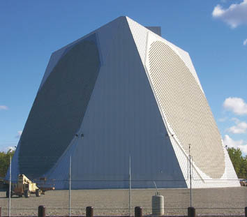
PAVE PAWS Phased array Radar that replaced BMEWS at Clear AFS, Alaska.


Air Force technicians work at tracking monitors in the Tactical Operations Room on the Thule BMEWS.
The original sites used two types of radars, the UHF range/425 MHz AN/FPS-50, with four (at Site 1) or three (at Site 2) fence antennas for initial detection, each 165 feet (50 m) tall and 400 feet (120 m) wide, and UHF range/425 MHz AN/FPS-49, later upgraded to AN/FPS-92, fully steerable tracking dish, 85 feet (26 m) in diameter, installed in a large radome. One fence antenna covered a 40-degree sector of the horizon, for a total site coverage of 120 degrees.
A prototype of BMEWS, located in Trinidad, began providing surveillance and tracking of ballistic missiles by 1958, and went operational on February 4, 1959, to gather data on missiles fired at the Atlantic Missile Range, as well as satellites and meteors. The full BMEWS radar network became operational in the early 1960s. Each site had dual IBM 7094 computers for signal processing and impact prediction.
RCA manufactured and maintained the electronics utilizing an RCA 501 computer with 32k "high speed memory", 5-76KC 556 bpi 3/4" tape drives and a 200 track random access LFE drum to maintain wire connection lists at RCA's Astro Electronics Division facility in Hightstown, NJ. Every wire was able to be traced from origin to destination with software and the weight of the cable interconnecting cabinets was automatically calculated by an RCA 501 machine language program named "signal path" written by Robert Goerss, computing facility director.
A fully characterized signal, designating an incoming missile, was known among the engineers as a "Q point". Having a "Q point" emerge on the screens meant that missile warning systems and missile defense systems would be activated. The designation arose because on the flow charts used to indicate how radar signals were processed, the full designation of an incoming missile was achieved at Point Q on the chart. Therefore, engineers rarely spoke of missiles, but instead talked about Q Points.
The system at Thule was erected on permafrost, i.e., permanently frozen ground. The antennas were built atop large concrete platforms—about the size of a football field, for the detection antennas. Concrete cures exothermically, so that pouring that much concrete would have caused the permafrost to melt and the concrete pad thus to sink or tilt. To counter that problem, one of the largest refrigeration systems ever built was installed, with the refrigeration piping embedded in the concrete when it was poured. The refrigeration was operated steadily from the first moment of pouring concrete until the entire pour had solidified and cured. This cooling offset the heat of the concrete curing, stabilizing the platforms. The system had no use after the concrete had cured, and this massive refrigeration system was therefore scrapped after a single use.
The Soviet Union developed a Fractional Orbital Bombardment System (FOBS) in part to counteract the network of sensors covering the northern hemisphere, including BMEWS, which was only able to point in a fixed direction. FOBS placed a warhead in low earth orbit, reducing the line-of-sight ranges tremendously compared to the traditional "lofted" trajectories of a conventional ICBM. Additionally, the FOBS could be launched southward, overflying most of the globe and then approaching the U.S. from the south, where it would be invisible to BMEWS. Submarine-launched ballistic missiles also avoided detection by BMEWS, developing into a credible threat in the 1970s. The Defense Support Program (DSP) early warning satellites were developed in part to counter this threat, detecting the infrared "bloom" from the launch rockets no matter where they occurred.
Moon alarm[]
On October 5, 1960, the moonrise occurred directly in the path of the Thule detection radar, producing a strong signal return. While the computer system never generated an impact prediction, the large amount of data caused enough concern that the equipment was subsequently modified to reject moon returns based on their long (2.5 second) delay.
Upgrades[]
The Thule and Fylingdales sites were upgraded with phased array radars in the 1990s. BMEWS 3, located in RAF Fylingdales, was upgraded by Raytheon/Cossor AeroSpace and Control Data Corporation at a cost of US $100M. The new antenna was a three-faced phased array antenna providing 360 degrees of coverage. The embedded computer was a CDC-Cyber running JOVIAL. The Clear, Alaska, site was upgraded in 2001 with a PAVE PAWS radar that was originally located at Eldorado Air Force Station, Texas. The phased array radars operate in the 420-450 MHz () frequency range.
Along with the PAVE PAWS radar sites at Cape Cod Air Force Station on Cape Cod, Massachusetts41°45′09″N 70°32′19″W / 41.7524°N 70.5386°W, Beale Air Force Base, California39°08′10″N 121°21′02″W / 39.1361°N 121.3506°W and the PARCS radar at Cavalier AFS, North Dakota48°43′29″N 97°53′59″W / 48.7246°N 97.8998°W, the BMEWS sites provide continual ground-based missile warning for the United States and Canada, with satellite surveillance as a secondary role.[2]
See also[]
- White Alice Communications System
- Nuclear weapons and the United States
- PAVE PAWS
- Globus II
- Missile Defense Alarm System
- Space-Based Infrared System (SBIRS)
- Defense Support Program
- United States Space Surveillance Network
- Distant Early Warning Line
- North Atlantic Radio System
- ACE High
- Pinetree Line
- Mid-Canada Line
- List of USAF Aerospace Defense Command General Surveillance Radar Stations (SAGE)
- Joint Surveillance System (JSS)
- Specific US radar and locations
- Cobra Dane, Eareckson Air Station, Alaska
- Thule Air Base, Greenland
- Clear Air Force Station, Alaska
- RAF Fylingdales, United Kingdom
- Cape Cod Air Force Station, Massachusetts
- Beale Air Force Base, California
- Cavalier Air Force Station, North Dakota
- "Texas Towers" North Atlantic offshore radar platforms
- Specific US radar and locations
References[]
- ↑ Pave PAWS System
- ↑ Clear AFS Mission See alternate Clear AFS site
- Alternate Clear AFS, See Global's Clear AFS
- The Moon as a Soviet Missile Attack. http://taihendaro.cynic.net/2010/01/moon-as-soviet-missle-attack.html
- Nuclear Files. 20 Mishaps That Might Have Started Accidental Nuclear War http://www.nuclearfiles.org/menu/key-issues/nuclear-weapons/issues/accidents/20-mishaps-maybe-caused-nuclear-war.htm
External links[]
- Historic American Engineering Record (Library of Congress) (HAER AK-30-A) - Clear Air Force Station, Ballistic Missile Early Warning System Site II
- A detailed personal account of BMEWS
- Global's Space Systems information with pictures
- BMEWS Program overview from 1997
The original article can be found at Ballistic Missile Early Warning System and the edit history here.