| 53d Weather Reconnaissance Squadron | |
|---|---|
 WC-130J of the 53d WRS | |
| Active | 1944–1947, 1951–1960, 1962–1991, 1993–present |
| Country | United States |
| Branch | United States Air Force |
| Type | Squadron |
| Role | Tropical storm weather reconnaissance |
| Size | 10 aircraft, 20 flight crews |
| Garrison/HQ | Keesler Air Force Base, Mississippi |
| Nickname(s) | Hurricane Hunters |
| Commanders | |
| Current commander | Lt. Col. Gregory H. Lufkin |
| Insignia | |
| Emblem of the 53d Weather Reconnaissance Squadron |
 |
| Aircraft flown | |
| Reconnaissance |
WC-130J Hercules WC-130A/B/E/H/ Hercules WB-47E Stratojet WB-50D Superfortress WB-29A/B-29A Superfortress RB-17/TB-17 Flying Fortress B-25/WB-25D Mitchell |

A WC-130J Hercules aircraft weather loadmaster of the 53d WRS performs pre-engine start-up inspection in St. Croix, Virgin Islands, on 16 September 2010. The SFMR antenna housing is visible under the starboard wing outboard of the number four engine.
The 53d Weather Reconnaissance Squadron (AFRC), also known by its nickname, Hurricane Hunters, is a flying unit of the United States Air Force, and "the only Department of Defense organization still flying into tropical storms and hurricanes."[1] Aligned under the 403d Wing of the Air Force Reserve Command (AFRC) and based at Keesler Air Force Base, Mississippi, it flies aircraft into tropical cyclones in the Atlantic Ocean, the Caribbean Sea, the Gulf of Mexico and the Central Pacific Ocean for the specific purpose of directly measuring weather data in and around those storms. The 53d WRS currently operates the Lockheed WC-130J aircraft as its weather data collection platform.
The squadron was activated in 1944 during World War II as the 3rd Weather Reconnaissance Squadron, tracking weather in the North Atlantic between North America and Europe. Redesignated the 53d Weather Reconnaissance Squadron in 1945, the term "Hurricane Hunters" was first applied to its activities in 1946. The 53d became a part of the USAF before its inactivation in 1947, was reactivated in 1951 as a long range weather reconnaissance unit based in Bermuda and England, and since 1963 has been based in the southern United States or Puerto Rico with its primary mission the measurement of tropical cyclones. The 53d WRS moved to its present home station at Keesler AFB in 1973, and after being briefly inactivated again between 1991 and 1993, became an Air Force Reserve unit.
The Hurricane Hunters of the Air Force Reserve are distinct from those of the Department of Commerce's NOAA Hurricane Hunters, based at MacDill AFB, Florida, which uses Lockheed WP-3D Orion and Gulfstream IV-SP aircraft for weather reconnaissance, data collection and scientific research missions. In accordance with its memorandum of agreement with NOAA, AFRC maintains a capability in the 53d WRS for five sorties per day from its home station and two deployed locations in support of requirements for the National Hurricane Operations Plan, or two sorties a day during winter storm seasons. The 53d also provides a subunit, the Chief, Aerial Reconnaissance Coordination, All Hurricanes ("CARCAH"), at the National Hurricane Center to coordinate the activities of both organizations.[2]
Concurrent with its operational mission, the 53d WRS is also tasked with recruiting, organizing and training assigned personnel to perform aerial weather reconnaissance, and its air crews are qualified to handle tactical airlift missions.
History[]
All data from Air Force Historical Research Agency[3]
Lineage[]
- Constituted 3d Weather Reconnaissance Squadron, Air Route, Medium on 7 August 1944
- Activated on 31 August 1944
- Redesignated 3d Reconnaissance Squadron, Weather, Heavy on 26 January 1945
- Redesignated 53d Reconnaissance Squadron, Long Range, Weather on 15 June 1945
- Redesignated 53d Reconnaissance Squadron, Very Long Range, Weather on 27 November 1945
- Inactivated on 15 October 1947
- Redesignated 53d Strategic Reconnaissance Squadron, Medium, Weather on 22 January 1951
- Activated on 21 February 1951
- Redesignated 53d Weather Reconnaissance Squadron on 15 February 1954
- Discontinued on 18 March 1960
- Organized on 8 January 1962
- Inactivated on 30 June 1991
- Activated in the Air Force Reserve Command on 1 November 1993
Assignments[]
|
|
Stations[]
|
|
Aircraft operated[]
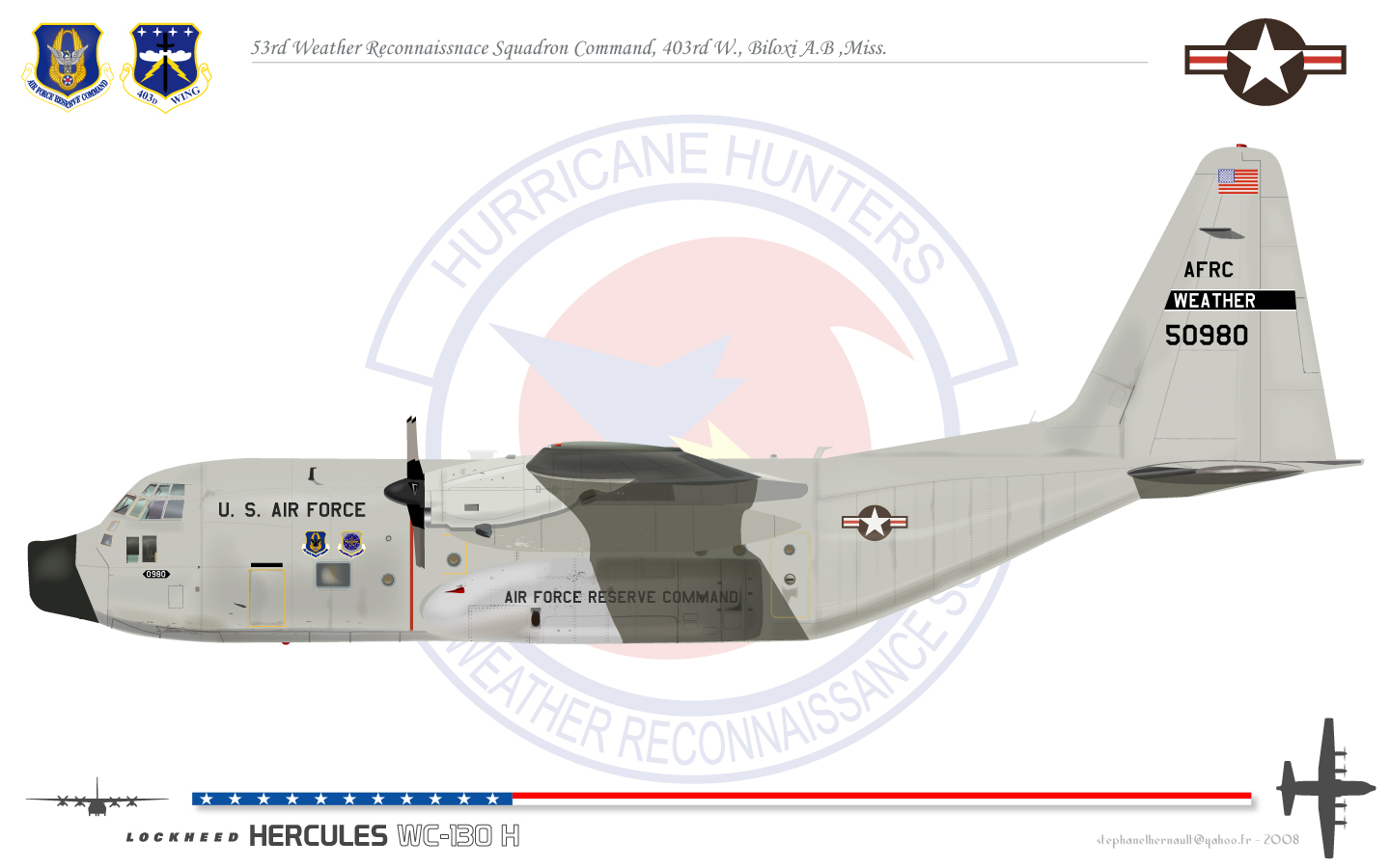

53d WRS WC-130H
- WC-130J Hercules, (1999–present)
- WC-130A/B/E/H Hercules, (1965–2006)
- WB-47E Stratojet, (1963–1969)
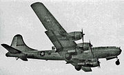
- WB-50D Superfortress, (1956–1960, 1962–1963)
- WB-29A Superfortress, (1951–1956)
- B-29 Superfortress, (1946–1947)
- RB-17/TB-17 Flying Fortress, (1945–1947)
- B-25/WB-25D Mitchell, (1944, 1946–1947)[4]
Operational history[]
The 1943 Surprise Hurricane, which struck Houston during World War II, marked the first intentional meteorological flight into a hurricane. That summer, British pilots being trained as instrument instructor pilots at Bryan Army Airfield heard that the school was evacuating its AT-6 Texan trainers in the face of the oncoming hurricane, and began teasing their instructors about the airworthiness of the aircraft. Instrument flying school commander USAAF Lt. Col. Joseph B. Duckworth, a former airline pilot with Eastern Airlines who had developed instrument procedures for the carrier, bet his RAF students that he could safely fly into the storm and return. On 27 July 1943 he took out one of the trainers with 2nd Lt Ralph M. O'Hair navigating and flew it straight into the eye of the storm. After he returned safely, the base's only weather officer, 1st Lt William H. Jones-Burdick, took over the navigator's seat and Duckworth flew into the storm (now over land) a second time, this time recording their observations and measuring temperatures within the storm.[5][6] The flights demonstrated that hurricane reconnaissance flights were feasible.[7][8]
24 days later, on 19 August 1943, the AAF weather station at Waller Field, Trinidad, recorded unusually low pressures and received a similar report from Beane Field on Saint Lucia. Together with a report of high winds to the east from a U.S. Navy aircraft landing at Naval Operating Base Trinidad, the data prompted the first weather reconnaissance mission to locate a previously unreported tropical disturbance, which was flown the next morning. The flight, made by a B-25 Mitchell medium bomber assigned to the 25th Bombardment Group (an anti-submarine unit at nearby Edinburgh Field), proceeded from Waller to Barbados and then due east at altitudes between 8,000 ft (2,400 m) and 600 ft (180 m) into the heart of Hurricane III of 1943. Using standard navigational position fixes, the mission plotted observations inflight on a chart as they proceeded and transmitted them to Beane Field for relay to Waller and Borinquen Field, Puerto Rico.[n 1][9]
The 53d WRS was originally activated in 1944 at Presque Isle Army Airfield, Maine, as the 3 WRS.[3] Many of its missions were flown from a forward base at Gander, Newfoundland, using B-25s. Its original mission was to fly weather tracks along aircraft ferry routes between North America and Allied Western Europe. During the 1946 season, when the 53d WRS acquired the RB-29 (later WB-29) Superfortress as its primary aircraft, the term "Hurricane Hunters" was first used to describe its missions. While not an ideal weather reconnaissance platform, the WB-29 proved to be comparatively safe and reliable. The first medium level penetration of a hurricane took place on 19 October 1947 by an RB-29 of the 53d WRS into Hurricane Love near Bermuda, validating penetration of tropical storms at lower altitudes as reasonably safe.[4]
From Gander, the squadron moved to New Hampshire; Florida; Kindley Field, Bermuda; RAF Burtonwood, England, with forward basing at Dhahran, Saudi Arabia; Bermuda for a short time, and Hunter AFB, Georgia. In 1966, now flying the Lockheed WC-130, the 53d WRS once again left the United States, this time for Ramey AFB, Puerto Rico. When Ramey closed in 1973, the Hurricane Hunters relocated to their present location at Keesler AFB, Mississippi.[7]

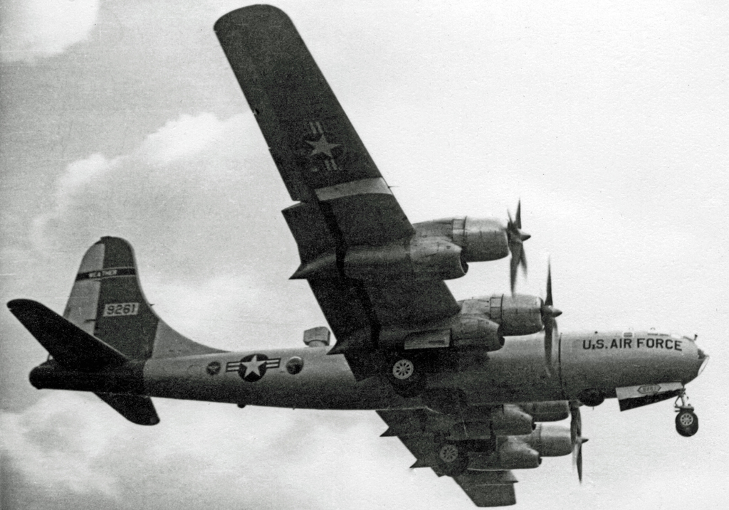
53d WRS WB-29A weathership landing at its base at RAF Burtonwood in 1954

53d WRS WB-50D weathership landing at RAF Burtonwood in 1956. The observation and sampling station is on top of the rear fuselage
On 18 September 1953, while based at Kindley AFB, Bermuda, the squadron suffered its only mission-related loss of an aircraft, a WB-29. Returning to base with a runaway propeller on the inboard engine of the right wing, the propeller separated from its shaft and struck the engine beside it, causing both the wing and outboard engine to catch fire. The pilot ordered an immediate bailout, but the aircraft went out of control and only three of the 10-man crew survived.[10][n 2]
In 1976, the 815th Tactical Airlift Squadron of the Air Force Reserve, also based at Keesler, was redesignated the 815th Weather Squadron "Storm Trackers" and served as an associate squadron to the 53d until 1987, when the 815th reverted to a tactical airlift unit. The Regular Air Force's 53d WRS was inactivated in June 1991 for budgetary reasons and its mission assumed by the 815th TAS, which continued its airlift role as well. On 1 November 1993, the 53d WRS was reactivated as an Air Force Reserve squadron to take over the weather reconnaissance mission from the 815th AS.[11]
The WC-130H airframes flown by the 53d WRS were originally built in 1964–65 as C-130Es. 1992's Hurricane Andrew demonstrated a need for upgraded models to continue the mission, and funding for ten replacements was authorized by Congress in FY1998. On 11 October 1999, the 53d WRS received its first WC-130J, and flew its first hurricane mission in the new model on 16 November, into Hurricane Lenny. Problems with the new model, primarily damage to its composite material 6-bladed propellers from hail and ice and a lack of sensitivity in its color radar images, delayed its Initial Operational Capability until just before the 2005 hurricane season. The propeller problem was overcome by bonding a metal sleeve to the leading edge of each blade and the radar issue by changes in the radar software coding.[12]
While in conversion to the new airframe, the unit continued its mission of aerial weather reconnaissance and added a new weather-related mission type in 2003, using the WC-130Js to drop buoys ahead of impending tropical storms. In 2004, the unit started training to support tactical airlift missions in addition to its weather mission. The landfall of Hurricane Katrina on 29 August 2005 caused devastating damage to Keesler. An estimated one-third of the members of the parent 403d Wing lost a home or had it extensively damaged.[13] Yet the equipment and personnel of the squadron, flying out of Dobbins Air Reserve Base near Atlanta, Georgia when the hurricane struck, never missed a tasked mission during Katrina or followup storms.[7]
The operations of the 53d WRS were affected by the federal budget sequestration of 2013. Furloughs of personnel, amounting to two days in every pay period per member, resulted in a 20% cut in capability, according to the wing commander of the 403d Wing on 24 July 2013. In practice this meant the squadron would be capable of working only two storms simultaneously at full mission scheduling instead of the normal three, and that pace sustainable only for five or six days. Further demands on the squadron within the same period would result in prioritizing storms or flying fewer missions in tracking the systems.[14]
Hurricane Hunter mission[]
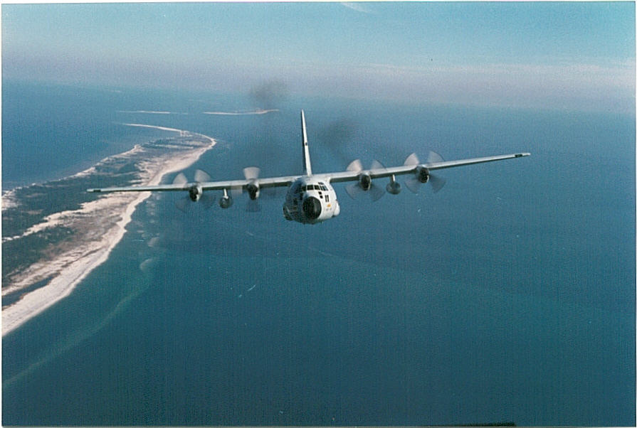

WC-130H Hercules in flight


WC-130J Hercules on the ramp at Dobbins ARB, Georgia, with another landing behind it, during reployment for Hurricane Katrina.[15]
The 53d Weather Reconnaissance Squadron, using the call sign Teal, flies missions into hurricanes and weather systems for research purposes and observation. Although satellite data has revolutionized weather forecasters' ability to detect early signs of tropical cyclones before they form, there are still many important tasks for which this information is not suitable. Satellites cannot determine the interior barometric pressure of a hurricane, nor provide accurate wind speed information. These data are needed to accurately predict hurricane development and movement. Because satellites cannot collect the data and ships are too slow and vulnerable, the only viable way to collect this information is with aircraft. Meteorological parameters measured, in order of priority, are:
- Geographical position of the flight level vortex center (vortex fix) and relative position of the surface center, if known;
- Center sea-level pressure determined by dropsonde or extrapolation from within 1,500 feet (460 meters) of the sea surface or from the computed 925 hPa, 850 hPa, or 700 hPa height;
- Minimum 700, 850 or 925 hPa height, if available;
- Wind data (continuous observations along the flight track) for surface and flight level;
- Surface wind data from Stepped-Frequency Microwave Radiometer (SFMR);
- High density three-dimensional Doppler radial velocities of the tropical cyclone core circulation;
- Temperature at flight level;
- Rain rate from SFMR;
- Sea-surface temperature; and
- Dew-point temperature at flight level.[16]
The 53d WRS is equipped with ten pallet-instrumented[n 3] WC-130J aircraft to collect the required meteorological data.[n 4] The area of responsibility for the "Hurricane Hunters" is from midway through the Atlantic Ocean west to the Hawaiian Islands, although they have also been tasked to fly into typhoons in the Pacific Ocean on occasion, as well as gather data in winter storms.[n 5] The Hurricane Hunters are tasked to support 24-hour a day continuous operations with the ability to fly up to 3 storms at a time with a response time of 16 hours. This necessitates a mission organization of ten full-time aircrews and ten part-time. Crews train twice monthly at Keesler AFB and fly weather recon missions when available. The WC-130J employs a standard five person crew element of a pilot, co-pilot, navigator, aerial reconnaissance weather officer (ARWO), and a weather loadmaster/dropsonde operator, with a second loadmaster assigned when required. The ARWO is the flight meteorologist and acts as flight director inside the storm system.[17]
The 53d WRS uses Henry E. Rohlsen Airport on St. Croix as its primary forward-deployed location for North Atlantic basin operations. Each May since 1996, when it switched operations from Antigua to the U.S. Virgin Islands to operate from U.S. soil, the squadron prepositions maintenance equipment and materiel at Rohlsen in preparation for the coming season. From July through September three crews are commonly forward-deployed to St. Croix at any given time with rotations of a week's deployment per month.[18] Since 1969, the 53d WRS also performs winter storm weather reconnaissance off both coasts of the United States between 1 November and 15 April in support of the National Centers for Environmental Prediction. These missions are flown at the WC-130's service ceiling of 30,000 ft (9,100 m), which subjects them to turbulence, lightning and icing. The crews collect data ahead of weather systems, dropping weather buoys along their routes, before they move off the eastern seaboard to help determine if the conditions are right to intensify into Nor'easter blizzards. In 1997 and 1998, the Hurricane Hunters also flew winter storms in the Gulf of Alaska. The predetermined tracks are six to eleven hours in duration, with one to three missions flown per major winter storm event.[19] Coverage of winter storms in the eastern Pacific has become standard during the month of February, operating TDY from either Elmendorf AFB, Alaska, or Hickam AFB, Hawaii.[20]
The 53d WRS works closely with the National Hurricane Center (NHC), a division of the National Weather Service (NWS) located in Miami, that tracks hurricanes to provide early warning service for Atlantic basin storms. It maintains a subunit, the Chief, Aerial Reconnaissance Coordination, All Hurricanes (CARCAH), at the NHC as a point-of-contact and provides the staff and equipment to coordinate Department of Commerce requirements for hurricane data, assign weather reconnaissance missions and monitor all data transmitted from weather reconnaissance aircraft of DOC and the 53d WRS.[7] To that end CARCAH is responsible for producing, publishing, and coordinating the Tropical Cyclone Plan of the Day (TCPOD) during hurricane season.[21][n 6]
The 53d WRS maintains similarly configured satellite communications ground stations within CARCAH at the NHC and its facility at Keesler to receive and process data from the aircraft. The Keesler ground station is maintained as a backup to the primary system at NHC, which has greater data streaming capability, and would be manned by CARCAH personnel in the event of a long-term satellite communications failure at NHC. During temporary outages, 53d personnel at Keesler act as operators and relay data from the aircraft by land line to the CARCAH ground station. Processed data is transmitted to the Weather Product Management and Distribution System (WPMDS) of the Air Force Weather Agency at Offutt AFB, Nebraska, which then relays it to the NWS Telecommunication Gateway at Silver Spring, Maryland, for worldwide distribution. The Keesler site has direct communications capability with WPMDS in the event of land line/internet failure between Keesler and the NHC. The system also provides backup transmission paths to WPMDS using local NHC servers and satellite connection to Keesler in the event of internet outages, except if an outage originates at Offutt.[22]
Tropical cyclone operational profiles[]
When a tropical disturbance becomes suspect for development as a tropical or subtropical cyclone, the NHC assigns the system a temporary tracking ("Investigation") number[n 7] and requests the 53d WRS to investigate if the winds are blowing in a counterclockwise rotation, indicating a "closed system". This investigative mission is flown at an altitude of 500 ft (150 m) – 1,500 ft (460 m) above the ocean surface in a pattern designated by the ARWO aboard the mission WC-130 based on observed conditions.[n 8] The ARWO, using a stepped-frequency microwave radiometer (SFMR, or "smurf"),[20][23][n 9] continuously monitors ocean waves to determine wind speed and direction. The low-level wind and pressure fields provide an accurate picture for NHC forecasters. Once NHC determines that there is circulation within the disturbance, the mission becomes a sequentially-numbered "fix" mission, conducted initially every six hours by rotating flights in cooperation with NOAA missions, and then at three-hour intervals as the storm moves within specified parameters.[17][n 10]
During the "fix" mission, the ARWO directs the aircraft to the true center of the storm. In order to make a reliable evaluation of the size and configuration of the storm, the crew flies through it using "Flight Pattern Alpha" consisting of intercardinal headings with legs 105 nautical miles (190 km) in length.[n 11] The Alpha pattern is repeated at least twice during the mission, which will typically see a penetration of the eye of the system four times. Patterns may also be adjusted to meet circumstances encountered in the system. In August 2011, as Hurricane Irene neared the Delmarva Peninsula between landfalls, a 53d WRS ARWO directed a pattern with shorter legs and more rapid turnarounds because of the proximity of land, making seven center fixes in one flight.[13] Flight weather data is continuously collected and sent directly to the NHC by satellite communications. Since the WC-130J is not equipped for aerial refueling, the alpha pattern continues until minimum fuel reserve is reached, or until the NHC has received all the data it requires.[17]
Major hurricanes (category 3 or above) are entered at approximately 10,000 ft (3,000 m) altitude.[n 12] While penetrating the eyewall, a dropsonde is released to determine the maximum winds at the surface and a second dropsonde is released in the eye to detect the lowest pressure at the surface. After exiting the eye, the ARWO creates a Vortex Data Message that includes the precise latitude and longitude of the storm center as well as its maximum winds, maximum temperature, and minimum sea level pressure.[n 13] The average duration of a "Hurricane Hunter" mission is ten hours, with five to six hours on station, depending on the distance of the storm from base, when tasked to perform three fixes at three-hour intervals.[13]
Decorations[]
All data from Air Force Historical Research Agency[3]
![]()
- 23 May – 31 October 1945
![]()
|
|
Cable television series[]
The Weather Channel announced in January 2012 that it would be presenting a six-episode docu-reality series (Hurricane Hunters) in July 2012 depicting the operations of the 53d WRS during the 2011 hurricane season.[24] However even before its debut, the series and its network were beset by controversy when a 53d WRS member, Major (then Captain) Nicole L. Mitchell, an ARWO and an on-camera meteorologist for TWC from July 2004 to January 2011, revealed on 4 June 2012 that she had filed suit 9 September 2011 in the United States District Court for the Northern District of Georgia against The Weather Channel and its owners, NBC Universal and two private equity firms, Bain Capital and the Blackstone Group, claiming that the termination of her employment in 2010 was based on her part-time Air Force Reserve service, was discriminatory and was in violation of the Uniformed Services Employment and Reemployment Rights Act (USERRA) of 1994.[25] A second nine-segment season, filmed in August and October 2012, aired on The Weather Channel beginning in June 2013.[26]
See also[]
- Tropical cyclone
- NOAA Hurricane Hunters
- National Hurricane Center
- Storm chasing
Notes[]
- Footnotes
- ↑ The B-25, AAF s/n 43-5052, was flown by Capt. R.A. Field of the 10th Bombardment Squadron and carried weather officers Major I.I. Porush, Captain J. R. Fleming, and 1st Lt. P.W. Allen. A second flight, similar to Duckworth's, took off from Antigua with weather officer Capt. C.H. MacDougall aboard and also observed the storm.
- ↑ The WB-29 was AF s/n 44-62277, a converted B-29A.
- ↑ Pallet instrumentation for the WC-130J's mission consists of a Communication Navigation Identification Unit (CNIU), Satellite Communication System (SATCOM), Advanced Vertical Atmospheric Profiling System (AVAPS) to receive and analyze dropsonde data, Atmospheric Sounding Processing Environment (ASPEN), and the Aerial Reconnaissance Weather Officer's computer with Weatherbird software package, all of which are described in External Links. Between May 2007 and February 2008 all ten WC-130J Weatherbirds were also equipped with wing-mounted Stepped-Frequency Microwave Radiometer ("Smurf") pods, described separately. In 2009 the SFMR systems were retrofitted with a new antenna that during heavy rains resulted in an over-calculation of light winds, caused by water intrusion in the radome through drain holes in the new antenna. The problem was identified during Hurricane Felicia and found to have affected 50% of missions flown during the season. It was corrected in September 2009 by sealing the drain holes.
- ↑ AF s/n 96-5300 through −5302, 97–5303 through −5306, 98–5307 and −08, and 99-5309.
- ↑ The squadron previously tasked for tropical storm reconnaissance in the Western Pacific, the 54th Weather Reconnaissance Squadron, was inactivated in 1987.
- ↑ The TCPOD is available at http://www.nhc.noaa.gov/ by clicking on Aircraft Recon under "Tools & Data" for Plan of the day.
- ↑ Numbers 90 through 99 in the cyclone numbering system are reserved for such disturbances. Although not required, the "90" series of cyclone numbers is assigned sequentially and normally reused throughout the calendar year. The number is further modified by a two-letter ocean basin code. Investigation AL97 (or "97L" in verbal shorthand) would be the seventh sequential disturbance in the North Atlantic basin, while Invest. EP92 (92E) is the second in the East Pacific basin north of the equator.
- ↑ "Suggested" investigative patterns are the X, Box, and Delta patterns, described and illustrated at NHOP 2013, pages 5–20 and 5–21.
- ↑ The SFMR is designed to continuously measure surface winds directly below the WC-130J, and is installed on the aircraft within a wing-mounted antenna pod. As the plane flies through a storm, the SFMR senses microwave radiation naturally emitted from foam created on the sea by winds at the surface. Computers determine wind speeds based on the levels of microwave radiation detected, extrapolated from the winds at the aircraft's altitude or from a dropsonde released from the aircraft. The SFMR can also determine rainfall rates within a system, which in addition to wind speeds at flight level, provides structural detail of the storm.
- ↑ A typical weather reconnaissance Tropical Cyclone Plan of the Day (TCPOD) is reproduced here. Up to four 6-hour fixes per day are conducted when a system is within 500 nautical miles of landfall and west of 55°W in the Atlantic, and up to eight 3-hour fixes per day if within 300 nautical miles of the coast of the United States, Hawaii, Puerto Rico, the Virgin islands, or DOD installations. Up to two "synoptic surveillance" missions per day may be flown on the periphery of systems with a potential for landfall. (NHOP 2013, p. 5-12).
- ↑ "5.8.1. Flight Pattern ALPHA Operational Details. 5.8.1.1. Flight Levels and Sequence. Flight levels will normally be 1,500 ft, 925 hPa, 850 hPa, or 700 hPa, depending on data requirements and flight safety. Legs will normally be 105 nm long and flown on intercardinal tracks (45 degrees off cardinal tracks). The pattern can be started at any intercardinal point and then repeated throughout the mission. Prior to starting an inbound or outbound track the aircrew should evaluate all available data, e.g., radar presentation, satellite photo, for flight safety. Once started on course, every effort should be made to maintain a straight track and the tasked altitude. A horizontal observation is required at each leg end point. This data is transmitted immediately. The ALPHA pattern may be modified to satisfy unique customer requirements (such as extending legs to examine the wind profile of a strong storm) or because of proximity of land or warning areas." (NHOP 2013, p. 5-19)
- ↑ Atmospheric pressure is determined by deviations from "standard levels" used by meteorologists worldwide. Stronger storms have lower pressures, and the lower the actual altitude from the standard level, the lower the pressure. The Hurricane Hunters use autopilot to fly a steady atmospheric pressure of 925 (2500 ft/762 m), 850 (4780 ft/1457 m), or 700 millibars (9880 ft/3011 m) of pressure. Storms of category 3 strength or greater are flown at 700mb. By using a radar altimeter to measure actual altitude above the surface, the ARWO calculates the "height of standard surface" reported to NHC to make these determinations.
- ↑ A description of the contents of the vortex data message is here. Standard sea level pressure is 1013 millibars. A "supplemental vortex data message" gives a cross-section of weather data at 15-nautical mile intervals, both inbound and outbound, along the 105-mile intercardinal legs to locate damaging winds in the storm's quadrants. Observation requirements are summarized in Table 5-1, page 5.5, National Hurricane Operations Plan 2013, linked below. During active tropical cyclones, the most current vortex data message can be found at http://www.nhc.noaa.gov/ by clicking on Aircraft Recon under "Tools & Data".
- Citations
- ↑ "NHC Aircraft Reconnaissance". National Hurricane Center. 2012. http://www.nhc.noaa.gov/recon.php. Retrieved 25 August 2012.
- ↑ "National Hurricane Operations Plan 2013". Office of the Federal Coordinator for Meteorology. http://www.ofcm.gov/nhop/13/nhop13.htm. Retrieved 12 May 2013., p. 5-4 and Appendix F.
- ↑ 3.0 3.1 3.2 "53 Weather Reconnaissance Squadron (AFRC)". AFHRA. http://www.afhra.af.mil/factsheets/factsheet.asp?id=10264. Retrieved 2 September 2010.
- ↑ 4.0 4.1 Robison, Tom. "The B-29 in Weather Reconnaissance". Air Weather Reconnaissance Association. http://www.awra.us/The%20B-29%20in%20Weather%20Reconnaissance%20by%20Tom%20Robison.htm. Retrieved 3 September 2010.
- ↑ Dr. Bob Sheets and Jack Williams (2001). Hurricane Watch: Forecasting the Deadliest Storms on Earth. Vintage. ISBN 0-375-70390-X., pp. 98–100
- ↑ Kaye, Ken (25 July 2013). "First 'hurricane hunter' flight was made on a bet". South Florida Sun-Sentinel. http://www.sun-sentinel.com/news/broward/fl-first-hurricane-flight-20130725,0,7436751.story. Retrieved 27 July 2013.
- ↑ 7.0 7.1 7.2 7.3 "53d Weather Reconnaissance Squadron 'Hurricane Hunters' Fact Sheet". 403rd Wing AFRC. http://www.403wg.afrc.af.mil/library/factsheets/factsheet.asp?id=7483. Retrieved 2 September 2010.
- ↑ Fincher, Lew, and, Read, Bill. "The 1943 "Surprise" Hurricane". NOAA.gov. http://www.history.noaa.gov/stories_tales/surprise.html. Retrieved 30 August 2010.
- ↑ Tannehill, Ivan Ray (1955). The Hurricane Hunters. New York: Dodd Mead. ISBN 0-39-60378-95., pp. 92-93
- ↑ "Gone, But Not Forgotten". Air Weather Reconnaissance Association. http://www.awra.us/gallery-may05.html. Retrieved 2 September 2010.
- ↑ "The History of the Hurricane Hunters". Hurricane Hunters Association.com. http://www.hurricanehunters.com/history.htm. Retrieved 2 September 2010.
- ↑ Robison, Tom. "Whiskey-Charlie". Air Weather Reconnaissance Association. http://www.awra.us/WhiskeyCharlie.html#10. Retrieved 3 September 2010., notes 10–11
- ↑ 13.0 13.1 13.2 Mitchell, Capt. N. L. (2013). "Into the Storm: A Hurricane Hunter Member Describes Her Missions in the Air While Her Concerns are For Those on the Ground". http://www.mydigitalrendition.com/publication/?i=139668&p=35. Retrieved 8 January 2013.
- ↑ Hurricane Hunters: Flying two storms difficult, three impossible, Danielle Thomas, WLOX-TV, Biloxi, MS (Retrieved 25 July 2013)
- ↑ "WC-130". aviation spectator.com. http://www.aviationspectator.com/more-aviation-photos?page=89&p1ff8age=17. Retrieved 5 September 2010.
- ↑ National Hurricane Operations Plan of 2013, p. 5-3.
- ↑ 17.0 17.1 17.2 "The Mission of the Hurricane Hunters". Hurricane Hunters Association.com. Archived from the original on 26 August 2010. http://web.archive.org/web/20100826005613/http://www.hurricanehunters.com/mission.html. Retrieved 30 August 2010.
- ↑ Joy Blackburn (17 May 2013). "Hurricane Hunters Are Back". The Virgin Islands Daily News, No. 22702. p. 1
- ↑ "53d Weather Reconnaissance Squadron". Global Security.org. http://www.globalsecurity.org/military/agency/usaf/53wrs.htm. Retrieved 2 September 2010.
- ↑ 20.0 20.1 "Hurricane Hunters". Hurricanes: Science and Society. http://hurricanescience.org/science/observation/aircraftrecon/hurricanehunters/. Retrieved 11 December 2012.
- ↑ National Hurricane Operations Plan of 2013, p. 5-5.
- ↑ National Hurricane Operations Plan of 2013, p. 5-25.
- ↑ "Stepped-Frequency Microwave Radiometer fact Sheet". 403d Wing AFRC. http://www.403wg.afrc.af.mil/library/factsheets/factsheet.asp?id=8314. Retrieved 12 December 2012.
- ↑ "The Weather Channel Premieres New Series Hurricane Hunters in July 2012". The Weather Channel. 2012. http://press.weather.com/press_detail.asp?id=375. Retrieved 12 June 2012.
- ↑ Folsom, Geoff (5 June 2012). "Suit alleges Weather Channel Star was fired for military service". The Marietta Daily Journal. http://www.mdjonline.com/view/full_story/18857115/article-Suit-alleges-Weather-Channel-Star-was-fired-for-military-service. Retrieved 12 June 2012.
- ↑ Schogol, Jeff (6 May 2013). "Reservist fired after returning from deployment". Air Force Times. http://www.airforcetimes.com/article/20130504/NEWS/305040003/Reservist-fired-after-returning-from-deployment. Retrieved 3 June 2013.
References[]
- Dr. Bob Sheets and Jack Williams (2001). Hurricane Watch: Forecasting the Deadliest Storms on Earth. Vintage. ISBN 0-375-70390-X.
- Fincher, Lew, and, Read, Bill. "The 1943 "Surprise" Hurricane". NOAA.gov. http://www.history.noaa.gov/stories_tales/surprise.html. Retrieved 30 August 2010.
- Mitchell, Capt. N. L. (2013). "Into the Storm: A Hurricane Hunter Member Describes Her Missions in the Air While Her Concerns are For Those on the Ground". http://www.mydigitalrendition.com/publication/?i=139668&p=35. Retrieved 8 January 2013.
- Robison, Tom. "The B-29 in Weather Reconnaissance". Air Weather Reconnaissance Association. http://www.awra.us/The%20B-29%20in%20Weather%20Reconnaissance%20by%20Tom%20Robison.htm. Retrieved 3 September 2010.
- Robison, Tom. "Whiskey-Charlie". Air Weather Reconnaissance Association. http://www.awra.us/WhiskeyCharlie.html#10. Retrieved 3 September 2010.
- Tannehill, Ivan Ray (1955). The Hurricane Hunters. New York: Dodd Mead. ISBN 0-39-60378-95.
- "53 Weather Reconnaissance Squadron (AFRC)". AFHRA. http://www.afhra.af.mil/factsheets/factsheet.asp?id=10264. Retrieved 2 September 2010.
- "53d Weather Reconnaissance Squadron 'Hurricane Hunters' Fact Sheet". 403d Wing AFRC. http://www.403wg.afrc.af.mil/library/factsheets/factsheet.asp?id=7483. Retrieved 2 September 2010.
- "Stepped-Frequency Microwave Radiometer Fact Sheet". 403d Wing AFRC. http://www.403wg.afrc.af.mil/library/factsheets/factsheet.asp?id=8314. Retrieved 12 December 2012.
- "Hurricane Hunters". Hurricanes: Science and Society. http://hurricanescience.org/science/observation/aircraftrecon/hurricanehunters/. Retrieved 11 December 2012.
- "The History of the Hurricane Hunters". Hurricane Hunters Association.com. http://www.hurricanehunters.com/history.htm. Retrieved 2 September 2010.
- "53d Weather Reconnaissance Squadron". Global Security.org. http://www.globalsecurity.org/military/agency/usaf/53wrs.htm. Retrieved 2 September 2010.
External links[]
- National Hurricane Operations Plan 2013; Chapters 5 and 6 deal with Aircraft Reconnaissance Operations
- 403rd Wing official website
- Hurricane Hunter Weather Equipment Fact Sheet
- 53d WRS image gallery (USAF)
- National Hurricane Center
- Hurricane Hunters Association homepage
- AF Reserve Hurricane Hunters, Facebook page maintained by 403rd Wing Public Affairs Office
- Air Weather Reconnaissance Association homepage
- Why and how people fly into hurricanes – USA Today – sidebar, "Fatal flights"
| |||||||||||||||||||||||||||||||||
_9261_MATS_Burtonwood_29.04.56_edited-2.jpg)
The original article can be found at 53d Weather Reconnaissance Squadron and the edit history here.