| 1987 Sino-Indian skirmish | |||||||
|---|---|---|---|---|---|---|---|
 The 1987 Sino-Indian skirmish occurred between the two Asian giants, China and India. | |||||||
| |||||||
| Belligerents | |||||||
|
|
| ||||||
| Commanders and leaders | |||||||
|
|
| ||||||
The 1987 Sino-Indian skirmish was the third military conflict between the Chinese People's Liberation Army and Indian Army that occurred at Sumdorong Chu Valley, with the previous one taking place almost a quarter of a century earlier.
Events leading up the near war[]
After her return to power in 1980 as Prime Minister of India, Indira Gandhi ordered a general review of India's security plans. In 1982-83, she approved a plan submitted by the Chief of the Army Staff, General K.V. Krishna Rao, to upgrade the sporadic deployment of forces along the Line of Actual Control with the People's Republic of China.
Since the late 1960s, India had developed an elaborate plan to defend the Himalayan frontier with China. This involved the provision of screening defences at the Line of Actual Control, or LAC, and the building of strong defence nodes at key points along the frontier. By the early 1980s, while the forces to man the defences were ready, the nodes were not, and the greatest weakness was in the fact that the servicing road network had not been built. The decision was taken to resume the defence infrastructure construction.
Since 1962, India had not returned to the site of its major defeat—the Namka Chu an east-west running stream which separates the Thag La and the Hathung La ridge to its south. India's efforts to occupy Thag La was the casus belli for the October 1962 Chinese military attack on India. Because there were no other feasible defensive locations north of Tawang, the government had more or less decided that in the event of a new war, they would abandon the town and prepare for battle at the Se La pass to its east. However, after the 1980 review, it was decided by the military strategists that it was important to defend Tawang in a future conflict.[3] The army made it clear that the only viable line of defence for Tawang would be along the Hathung La ridge. In 1983, an Intelligence Bureau team went to the pasturage of Sumdorong Chu which is north-east of the confluence of the Namka Chu and Nyamjiang Chu. The defence forces stayed through the summer and returned in winter. This procedure was followed for two years. In 1986, Indian forces found that the Chinese had preceded them and set up semi-permanent structures there.
In Feb 1986 the army nominated a new chief, General K. Sundarji, who was determined to press the decisions taken by General Krishna Rao. In addition, Sundarji sought government permission to conduct an exercise named Operation Chequerboard to see how quickly troops based in the Assam plains could take up their positions on the Sino-Indian border. As part of the exercise, towards the end of the year, the army landed a brigade of troops at Zimithaung, south of Hathung La using its new heavy lift Mi-26 helicopters. These forces occupied the Hathung La, across the Namka Chu from Thag La. All this alarmed the Chinese forces in the region; they responded with alacrity and moved up their forces to take up positions all along the LAC. At points near this area—Sulu La, Bum La, etc. the troops were now face to face with their Indian counterparts. This caused concerns of Sino-Indian clashes. However, the forces did not engage in combat.
Possibility of war[]
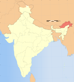
At the end of 1986, India granted statehood to Arunachal Pradesh, which is an area claimed by China but administered by India. The Chinese government proceeded to protest. But the military movements in Tawang, taken in conjunction with this political action were seen as a provocation by the Chinese. In early 1987 Beijing's tone became similar to that of 1962, and with the Indian Army refusing to stand down, Western diplomats predicted war.
The result was a thaw. Indian Foreign Minister N.D. Tiwari arrived in Beijing in May 1987 en route to Pyongyang, North Korea. He carried with him messages from Indian leaders that there was no intention on New Delhi's part to aggravate the situation. The first formal flag meeting to discuss “ the freezing of the situation” since 1962, was held on the fifth of August 1987 at Bum La in the aftermath of the Wangdung affair. Both sides decided to take up talks with renewed urgency and the following year, Rajiv Gandhi visited Beijing, returning Zhou Enlai's '60s visit.[4]
Aftermath[]
Both India and China realised the danger of inadvertent conflict and after initial posturing the decision was made to de-escalate their deployments. The Sumdorong Chu fallout was that India and China decided to restart their dialogue on a new and more urgent basis. After Rajiv Gandhi's September 1988 visit, there was a hiatus of sorts because of political turmoil in India. But finally in 1993, the two countries signed an agreement to ensure peace along the LAC.
The agreement brought in an interesting concept of "mutual and equal" security where thinning of forces was envisaged, based on geographical and logistical considerations. However, its most important element is to have the two sides work out a mutually acceptable Line of Actual Control. As of now the two sides have their own versions of the Line and there are points, especially in the Sikkim-Bhutan-India trijunction, the Sumdorong Chu area and so on where the claims are disputed.
References[]
- ↑ 1987中印边境冲突:印军最后时刻撤销攻击令 (1987 Sino-Indian skirmish military conflicts)
- ↑ India's China War, by Neville Maxwell
- ↑ [Manoj Joshi,"George In The China Shop" http://www.indiatodaygroup.com/itoday/18051998/cover.html]"India Today "[dead link]
- ↑ [Manoj Joshi,"Warrior as a Scholar" http://www.indiatodaygroup.com/itoday/22021999/obit.html]"India Today ".[dead link]
See also[]
| |||||||||||||||||||||||||
Coordinates: 29°12′35″N 94°28′57″E / 29.209713°N 94.482422°E
The original article can be found at 1987 Sino-Indian skirmish and the edit history here.